2025 Ultimate Orienteer #7 (Marmot O’ Cup Day 1) – Moses Lake (Middle)
ULTIMATE ORIENTEER
Saturday, June 21 at Moses Lake Sand Dunes in Moses Lake WA
Meet Director: Ing Uhlin
Event #7/8 in the Ultimate Orienteer Series! Day 1/2 of the Marmot O’ Cup |
Eastern Washington Doubleheader – Part 1
Head east for a doubleheader in Eastern Washington as we wrap up the Ultimate Series at Moses Lake and Fishtrap Lake! Our last visit to Moses Lake was in June 2017. The terrain here is fast and highly runnable, featuring rolling sand hills and offering plenty of route choices. However, it can be navigationally challenging if you don’t pay close attention to the details.
- June 21 – Moses Lake Sand Dunes, Middle
- June 22 – Fishtrap Lake, Long
Heat
Temperatures in the Moses Lake area in June can be very high. You should start your course as early as possible to avoid the heat. There will be one water control, but you are strongly advised to take water on the course with you.
Camping/Lodging
You can find a campground in the Moses Lake area or choose from a variety of hotels in Moses Lake. There is free camping at the Fishtrap Lake event site, albeit with no water and one vault toilet.
COURSES
Course designer(s): Peter Golde
Map scale 1:7,500. Contour interval 2.5 m.
| Course | Controls | Length |
| Beginner | 10 | 2.0 km |
| Intermediate | 13 | 2.4 km |
| Short Adv | 13 | 3.5 km |
| Medium Adv | 15 | 4.8 km |
| Long Adv | 20 | 6.5 km |
Middle Course/Class Assignments for Ultimate points
If you want to earn Ultimate points, check the table below to see which category you should sign up for. Find your age class in the left column, then follow the row across to the right until you find the dark orange cell. That is your “assigned” category.
For example, if you’re a female 16 or under, your Ultimate age class is F-16 and, for this event, is assigned to the Intermediate course. If you are up for a more challenging course, you can also earn points in F-18 on the Short Advanced course, or F-21+ on the Medium Advanced course. Just keep in mind that other courses are more difficult, both navigationally and physically. Also keep in mind that you’ll be earning points only in the class you sign up for.
| Age Class | Course |
| • Female 16 and Under • Open 16 and Under |
Intermediate |
| • Female 18 and Under • Open 18 and Under • Female 20 and Under • Female 50+ • Open 50+ • Female 70+ • Open 70+ |
Short Advanced |
| • Female 21+ • Open 20 and Under |
Medium Advanced |
| • Open 21+ | Long Advanced |
How are courses measured?
Courses are measured as the crow flies, in a direct line from control to control. Unless you have wings, you will travel farther than this distance! Courses are measured in kilometers, so a good rule of thumb is to simply round up to miles to estimate how far you will go. So in a 5 kilometer race, you’ll likely travel up to 5 miles.
COURSE NOTES
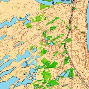
Welcome to Moses Lake Sand Dunes! We haven’t used this area in quite a few years, so it will likely be new to many of you. Although small (around 1.5 km2), its easy-to-run terrain, detailed sand dunes, and very limited trails make it a lovely orienteering area. Although it is physically not too difficult, you will probably find the navigation more tricky than you are used to in Winter League. It is a challenge to be able to navigate as fast as you can run here.
Terrain: This is open sand dune terrain with very few trees, although in most places there is light ground cover that makes the footing plenty firm. Occasional steeper areas can be sandy and trickier to get up and down. The ground cover is easy to run through, but has small barbs on it, so full leg cover is strongly recommended. There are no boulders or cliffs. Low areas have marshes and sometimes thick vegetation. The vegetation is generally not shown over the water/marsh symbol, so what looks like bushes from a distance may be mapped as a marsh or lake instead. Single trees and small bushes are not mapped. You will want to be always paying attention to the contour features, and knowing where you are; otherwise it can be easy to get quite confused. Although there are no extremely large hills, you will be going up and down the smaller dunes much of the time. Note that the contour interval is 2.5m instead of the more usual 5m. The few trails marked as intermittent (double dash) may be difficult to see or follow in places. You may see some game trails or very old trails that are not mapped; they don’t tend to run very far without fading away again.
Water Level: The water level here can change significantly, so it may not exactly match what is mapped. I have set the courses so they should be easily run regardless of the water level.
Start: There will be a run-out start. You will punch the start box to begin your timing, then run along the path to the trail bend, where there will be a control marker where the start triangle is on your map and where you begin navigating. There will not be a punch box at the start triangle.
Finish: After punching the finish, cross the fence and walk to the road, then north on the road back to the parking lot. Download at the parking lot. Do not forget to download, so we know that you have finished!
Map Flip: All courses except Beginner will have a map flip. Once you get to the last control on the front side of the map, flip it over and continue on the back side. We will check that you punched all controls in order, so looking ahead to the other side is unlikely to really help you, although it is not forbidden.
Heat: It can be hot in June, so plan ahead and don’t get dehydrated. There will be one water control on Short Advanced, Medium Advanced, and Long Advanced.
Road: There is a north-south road running through the entire area. Beginner and Intermediate will not need to cross the road; other courses will. Although traffic is very sparse, they do tend to drive fast so be alert. You will never be more than 300m from the road, so it is an excellent place to relocate if you get lost. If you want to quit or are injured, go to the road, then walk north back to the parking lot.
Fences: There are two fences roughly parallel to the road on both sides. Beginner and Intermediate will not need to cross the fences; other courses will. The east fence is not barbed and it is easy to cross over or slip between the wires. The west fence is barbed. If you are tall, you may be able to step over the top wire carefully. Otherwise, it is best to find a high spot and slip under the bottom wire on your back (take off any backpack first). Do not damage the fences.
SCHEDULE
9:00am-11:15pm – Check-in
9:30am-11:30am – Starts
9:30am-10:30am – Newcomer instruction
2:30pm – Courses close*
*Wear a watch to ensure that you return to the finish by course closure time, even if you have to abandon your course to do so. Those returning after course closure will be disqualified and will make the volunteer staff very grumpy.
Why is there a start window?
This event uses an interval start, which means that participants are started in waves instead of all at once. When you arrive at the start tent, find the chute for your course and follow the start volunteer’s instructions.
PRICES
PRE-REGISTRATION PRICES
$22 base price
– subtract $5 for CascadeOC members
– subtract $5 for using your own e-punch
Participating as a group? Just $5 for each additional adult (18+) group
member, no cost for additional minors. Max group size is 4 participants.
What’s an e-punch?
An e-punch records your race. At each control, you’ll dip the e-punch into an electronic box, which will beep and flash as confirmation. After you finish, you’ll download the e-punch at the download tent and get a receipt that show which controls you visited and how long you took between each; these are your “splits.”
Part of the fun of orienteering is comparing your splits with people who completed the same course, and discussing the routes you took!
SIGN UP
LOCATION
PARKING
Parking is available on site.
CARPOOL
Looking for a carpool? Join the club email group and share your request to find a ride.
THE MAP
First used for the 2010 US Orienteering Championships, this 1:10,000-scale map has a 2.5-meter contour interval, reflecting the subtle nature of the area’s topography.
Read more on the map pageSAFETY & ETIQUETTE
Return to the Finish
All participants MUST return to the finish and download their e-punch or turn in their punch card.
Even if you have not finished your course, you must still return to the the finish and confirm with event staff that you have returned safely.
Out of Bounds
Some areas may be marked out of bounds. It is imperative to respect these boundaries to maintain our relationships with land managers. Participants MUST NOT go out of bounds. Any participant caught going out of bounds will be disqualified.
Course Closure
All participants MUST return to the finish by course closure time. If a participant does not return by course closure, event volunteers will begin coordinating a search party.
If you need a long time on the course, start as early in the start window as possible, wear a watch, and be prepared to cut your course short to make it back by the course closure time.
Whistle
All participants MUST carry a whistle on the course. Complimentary whistles are available at the start tent (please only take one).
If you are injured on the course and need assistance, blow three long blasts to call for help.
If you hear a call for help, abandon your course to find the person in distress.
Voices
Part of the fun and fairness of orienteering is navigating your own course, so please be polite when you find a checkpoint and don’t holler that you’ve found it.


