The Ultimate Orienteer series is the sampler pack of orienteering: each event gives you the opportunity to try a different flavor!
The eighth event in the series is: ULTRA-LONG!
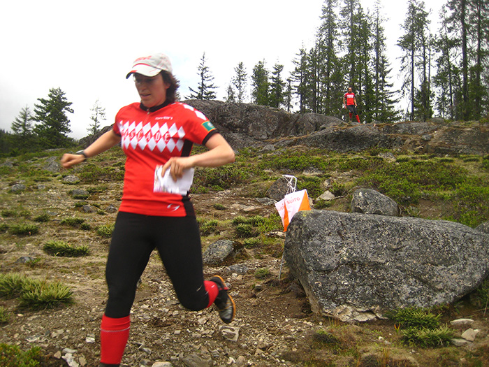
An Ultra-Long is indeed a very long orienteering race. While a distance like “10k” might seem short by road run standards, orienteering courses are measured as the crow flies, meaning that you might actually travel 10 miles on a 10-kilometer course because you’ll have to zig-zag between checkpoints. And of course, you won’t be jogging on a smooth road. Instead, you’ll be in the middle of the forest, picking through talus rock fields, and having a grand old time. This is why we love orienteering!
Add to that steep terrain with advanced navigational challenge, and you may want to bring a hydration pack, snacks, and a watch to make sure you get back by course closure time (2:30pm).
If it sounds intimidating, that’s okay. The key is to set your expectations for one long adventure, and you’ll have a ton of fun in this tough and beautiful venue. Check out this video that Rebecca Jensen made here in 2012!
COURSES
Course designer(s): Patrick Nuss
COURSE DISTANCES
Beginner – 3.4k, 10 controls, 70m climb
Intermediate – 3.3k, 9 controls, 115m climb
Short Advanced – 3.6k, 9 controls, 115m climb
Advanced – 6.2k, 21 controls, 260m climb
Long Advanced – 9.7k, 28 controls, 490m climb
ULTIMATE CATEGORIES
Below is the course/class structure for the Ultimate Orienteer Series:
Jr. Men/Women – Short Advanced
Masters Men/Women – Advanced
Open Men/Women – Long Advanced
START/FINISH DETAILS (Interactive map!)
Beginner, Intermediate, and Short Advanced courses will start and finish near the parking/registration area.
Advanced and Long Advanced courses require a shuttle to the trailhead and a 900m walk (with 125m of climb)
A shuttle will pick you up from the parking/registration area and drop you off at the Salmon La Sac trailhead, where you’ll walk the rest of the way to the start. Check the schedule for shuttle operation times. Allow 15 minutes for the shuttle ride and another 15 minutes to walk to the start.
All courses will finish at the parking/registration area.
How are courses measured?
Courses are measured as the crow flies, in a direct line from control to control. Unless you have wings, you will travel farther than this distance! Courses are measured in kilometers, so a good rule of thumb is to simply round up to miles to estimate how far you will go. So in a 5 kilometer race, you’ll likely travel about 5 miles.

COURSE NOTES by Patrick Nuss
Salmon La Sac is beautiful, rugged, and navigationally complex. There are many reasons why this venue tops the scales at 10/10 in both of CascadeOC’s physical and navigational ratings! The terrain consists of open runnable forest, giant slabs of rock, thousands of knolls, boulders, and cliffs, and some thicker areas of vine maple, downfall, and logging debris. Salmon La Sac poses a significantly greater technical and physical challenge than an average orienteering meet on a college campus or in a city park.
I have designed five courses, three of which can be conveniently accessed from the parking/registration area. If you’ve never orienteered at Salmon La Sac before, I recommend that you arrive early and try several of the shorter courses. The Beginner, Intermediate, and Short Advanced courses are all about 3.5km in length and have very few checkpoints in common. They are good opportunities to test and improve your navigation skills before you “head up the mountain” and attempt a more rugged course in the future.
The remaining two courses, Advanced and Long Advanced, are very difficult, and require both a shuttle from the parking/registration area to the trailhead, and a 900m walk up the hill to a remote start. These courses get to the best stuff on the map! These courses finish at the parking/registration area, which means that there’s a mandatory 800m route along the road through the out-of-bounds area in the middle of the map.
The Beginner course is entirely on trails and roads. The Intermediate course will require basic contour reading, and will have most checkpoints within 100 meters of trails and roads. The three advanced courses (Short Advanced, Advanced, and Long Advanced) will be almost entirely off trail, requiring detailed contour reading, and precise navigation to point features.
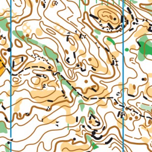
All maps are 1:10000 scale with a contour interval of 5m. All maps will be printed on 8.5 x 11″ waterproof paper. The Advanced and Long Advanced courses will be printed on two sides of the same sheet of paper. Everything north of the out-of-bounds area is on Map 1, and everything south of the out-of-bounds is on Map 2. There’s overlap between the two maps, so it’s straightforward.
The Long Advanced course can shortcut to become the Advanced course. These two courses share the first 6, and the final 15 controls. If you want to shortcut while you’re out there, just skip from control #6 (1.6km into the course) to control #14 on the Long Advanced course to get the Advanced course. This is noted in the control descriptions.
Update: a HUGE tree just fell across a trail that all five courses use near the registration/parking area. It is possible to go underneath, but it’s a little annoying.
Water: There is no water available on the three shortest courses. There will be two water controls on the longest courses: one is 1.6km from the start (control #6 on both courses) and another just before the mandatory road run (3.7km from the start on Advanced, 7.4 km from the start on Long Advanced). There will be water at the parking/registration area. It is still advisable to carry water with you on the course, especially if it is hot!
Safety Bearings: If you need to exit to safety, there are two different safety bearings for the two areas of the map. If you’re north of the out-of-bounds, then you’ll want to head south/downstream to the road, which will get you to the road or trailhead. If you’re south of out-of-bounds, you’ll want to head west to the Cle Elum River Road. These are noted on the maps.
Terrain & Map: This map was originally made in 2009 and is in generally good shape. The most recently logged areas have grown somewhat in 7 years, so mapped areas of rough open land with scattered trees can seem more light green in reality. There is vine maple in the deeper reentrants, but courses are designed around the worst of it (and they don’t have thorns, so it’s not too unpleasant). A lot of the map has quite nice and runnable woods and moss-covered slabs of rock!
Speaking of rock, there’s a lot of it, in many different forms. Giant slabs of moss-covered rock are mapped as open land. There are thousands of boulders, cliffs, and rocky knolls, not all of which are mapped. Boulders smaller than 1m in height are usually not mapped. Some rocky slopes (some covered in moss, some not quite steep enough) are not mapped as cliffs, just as contour lines. I’ve used a lot of rock features as control location on the advanced courses.
Ultra-Long: For those of you competing in the Ultimate Orienteer Series, this is the Ultra-Long event. Those who study Orienteering USA regulations will know that Ultra-Long courses should be at 1:15000 scale and “feature long legs, and route choice legs” on terrain with “high route choice potential and/or good rough map reading”. Ultra-Long courses “may contain a variety of technical difficulties, but no controls should be set solely for technical challenge” and “excessively thick or stony areas should be avoided”.
Well, Salmon La Sac is not really suited for a by-the-book Ultra-Long! Salmon La Sac has a very high technical challenge with a lot of stony areas, and the size and steepness of the terrain doesn’t lend itself well to massively long legs. This is special terrain, and I wanted to play to its strengths, so advanced courses will have a lot of technical controls on point features. The Long Advanced course does have two 1km legs to give it a little Ultra Long feel.
This is my third time designing courses here, and it’s my favorite place to set. I hope you’ll enjoy running the courses as much as I had designing them!
SCHEDULE
8:15am – Registration/check-in opens
8:30am – First shuttle leaves Registration area (Advanced and Long Advanced only)
9:00am – Starts open
11:00am – Registration closes
11:15am – Last shuttle leaves Registration area (Advanced and Long Advanced only)
11:30am – Starts close
2:30pm – Courses close*
*Courses at Salmon La Sac often take people much longer than they think. If you think you might take a long time on the course, start early in the start window. Also, wear a watch to ensure that you return to the finish by course closure time, even if you have to abandon your course to do so. Those returning after course closure will be disqualified and will make the volunteer staff very grumpy.
Why is there a start window?
This event uses an interval start, which means that participants are started in waves instead of all at once. When you arrive at the start tent, find the chute for your course and follow the start volunteer’s instructions.
PRICES
PRE-REGISTRATION PRICES
$17 base price
– subtract $5 for CascadeOC members
– subtract $5 for using your own e-punch
DAY-OF-EVENT REGISTRATION
$20 base price
– subtract $5 for CascadeOC members
– subtract $5 for using your own e-punch
What’s an e-punch?
An e-punch records your race. At each control, you’ll dip the e-punch into an electronic box, which will beep and flash as confirmation. After you finish, you’ll download the e-punch at the download tent and get a receipt that show which controls you visited and how long you took between each; these are your “splits.”
Part of the fun of orienteering is comparing your splits with people who completed the same course, and discussing the routes you took!
SIGN UP
Online pre-registration closes:
Day-of-event registration is available by cash or check, made payable to Cascade Orienteering Club
LOCATION
PARKING
Use the large gravel Sno-Park parking lot; do not park at the Salmon La Sac trailhead. No pass is required to park at the Sno-Park.
CARPOOL
Looking for a carpool? Join the Yahoo listserv and share your request to find a ride.
THE MAP
Salmon La Sac is Cascade’s most challenging map of all, both physically and navigationally.
The glaciated terrain produces incredibly detailed topographic features, which orienteers on Advanced courses must rely on, since trails are sparse. Plus, there are hundreds (thousands?) of point features, requiring detailed navigation to find. Add to that, Salmon La Sac is the steepest venue in the Cascade map catalogue, and off-trail travel is rocky and uneven.
Salmon La Sac is a beast of a venue, but it is also one of the most beautiful. High points on the course can surprise you with long vistas, and clearings are often bare rock covered in springy moss that you’ll want to stop and have a picnic on.
You may take much longer on a course at Salmon La Sac than you could have imagined, but if you bring water and snacks, it will be a welcome adventure.
Read more on the map pageSAFETY & ETIQUETTE
Return to the Finish
All participants MUST return to the finish and download their e-punch or turn in their punch card.
Even if you have not finished your course, you must still return to the the finish and confirm with event staff that you have returned safely.
Out of Bounds
Some areas may be marked out of bounds. It is imperative to respect these boundaries to maintain our relationships with land managers. Participants MUST NOT go out of bounds. Any participant caught going out of bounds will be disqualified.
Course Closure
All participants MUST return to the finish by course closure time. If a participant does not return by course closure, event volunteers will begin coordinating a search party.
If you need a long time on the course, start as early in the start window as possible, wear a watch, and be prepared to cut your course short to make it back by the course closure time.
Whistle
All participants MUST carry a whistle on the course. Complimentary whistles are available at the start tent (please only take one).
If you are injured on the course and need assistance, blow three long blasts to call for help.
If you hear a call for help, abandon your course to find the person in distress.
Voices
Part of the fun and fairness of orienteering is navigating your own course, so please be polite when you find a checkpoint and don’t holler that you’ve found it.


