Ultimate Orienteer #6: Classic
The Ultimate Orienteer series is the sampler pack of orienteering: each event gives you the opportunity to try a different flavor!
The sixth event in the series is: THE CLASSIC!
Before the specialties of sprint, middle, and long were developed, there was just the classic. Long in length and an all-around test of skills. Elite men may finish a classic in as “little” as 70-80 minutes, but mere mortals should plan on at least twice that time or more and carry a hydration pack and a snack.
DOUBLE HEADER
The Classic is the first part in a double-header weekend in the Teanaway valley. Join us on Saturday for the Classic, then stay for Sunday’s Score-O. There’s free camping nearby and a selection of hotels in Cle Elum.
COURSES
Course designer(s): Peter Golde
| COURSE | CONTROLS | DISTANCE | CLIMB |
|---|---|---|---|
| Beginner | 9 | 3.4 km | 40 m |
| Intermediate | 9 | 4.8 km | 110 m |
| Short Advanced | 12 | 4.4 km | 110 m |
| Long Advanced | 17 | 6.9 km | 210 m |
Short Advanced and Long Advanced are advanced in technical difficult, and are different only in length. Anyone running on Advanced should be comfortable navigating using only contour lines.
In orienteering, the venue has a large bearing on the difficulty of a course. Long Advanced at a city park is not equivalent in difficulty to Long Advanced in the mountains. If this is your first time at a rugged venue in the Cascades or Eastern Washington, consider running a shorter or easier course.
COMPETITION CATEGORIES
If you wish to participate in the Ultimate Orienteer series scoring, sign up for the corresponding course and you’ll automatically be entered into the series competition:
- 20 and under – Junior: Short Advanced Course
- 50 and older – Masters: Short Advanced Course
- Anyone – Open: Long Advanced Course
How are courses measured?
Courses are measured as the crow flies, in a direct line from control to control. Unless you have wings, you will travel farther than this distance! Courses are measured in kilometers, so a good rule of thumb is to simply round up to miles to estimate how far you will go. So in a 5 kilometer race, you’ll likely travel about 5 miles.
COURSE NOTES
Map scale: 1:10,000
Contour intervals: 5m
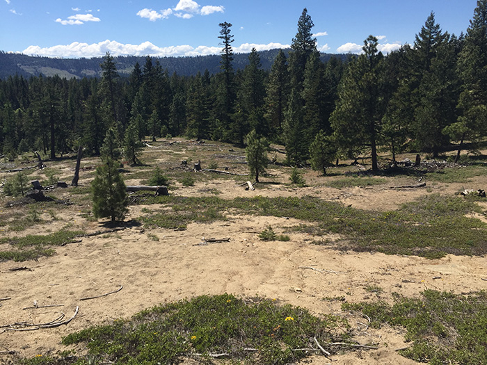
“I hope you will enjoy this beautiful and challenging area. Along with Lick Creek, this is my favorite orienteering area in Washington State, with a great combination of challenging contour navigation, open forest running, and not too much climb.
Please note that Short Advanced and Long Advanced are set to the same technical difficulty level, and differ only in length. You should only attempt one of the advanced courses if you are comfortable map reading and navigating via contour lines only. No matter what course you choose, it is crucial that you keep track of where you are on the map at all times; relocating in this area is very difficult if you make a mistake.
The map was last updated in 2009, but it still very usable as long as you keep that in mind. Rootstocks (brown X) and logging piles (brown circle with dot) should be ignored. Solid green areas are still roughly correct and useful to avoid. You will probably find it difficult to discern the difference between the forest (white), open land with scattered trees (checked yellow/white), and the rough open (light yellow). Some of the large clearings have been replanted with young trees. Contours, rocks/cliffs, and the larger trails and roads are your best bet for navigation.
The intermittent trails (double dashed lines) may exist but are often totally gone. All other trails should exist. The next smallest size trail (narrowest dashed line) may be hard to see until you are right on it but can be followed once you see it.
All courses will cross a barbed wire fence just south of the main east-west road at the bottom of the map. It may be hard to see; running into it at full speed is not recommended.
You will very likely see or hear deer and birds nesting on the ground, which can be startling but are harmless. There is a very slim chance you may encounter a bear. If you do, speak calmly to it so it knows you are human, retreat slowly, and do not run.”
-Peter
SCHEDULE
8:30am – Registration opens
9:00am – Start opens
There will be a half-mile walk uphill to the start (about 15 minutes)
11:15am – Registration closes
11:30am – Start closes
2:30pm – Course closes
All participants MUST return by course closure. If you think you will take a long time, please start as early in the start window as possible, and wear a watch to keep track of time.
Why is there a start window?
This event uses an interval start, which means that participants are started in waves instead of all at once. When you arrive at the start tent, find the chute for your course and follow the start volunteer’s instructions.
PRICES
PRE-REGISTRATION PRICES
$17 base price
– subtract $5 for CascadeOC members
– subtract $5 for using your own e-punch
DAY-OF-EVENT REGISTRATION
$20 base price
– subtract $5 for CascadeOC members
– subtract $5 for using your own e-punch
What’s an e-punch?
An e-punch records your race. At each control, you’ll dip the e-punch into an electronic box, which will beep and flash as confirmation. After you finish, you’ll download the e-punch at the download tent and get a receipt that show which controls you visited and how long you took between each; these are your “splits.”
Part of the fun of orienteering is comparing your splits with people who completed the same course, and discussing the routes you took!
SIGN UP
Online pre-registration closes: 9pm on Thursday, May 12
Day-of-event registration is available by cash or check, made payable to Cascade Orienteering Club
LOCATION
PARKING
A Discover Pass is required to park, and there is no on-site pay station. You can purchase a Discover Pass online and print a temporary pass until your pass arrives in the mail. You can also purchase a pass in-person at various retail locations. One-day and annual passes are available.
CARPOOL
Looking for a carpool? Join the Yahoo listserv and share your request to find a ride.
THE MAP
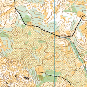
Part of a chain of orienteering maps in the Teanaway Community Forest, Teanaway Forks (or “Teanaway Valley”) is rugged, challenging, and beautiful. There is a fair amount of contour details and lots of open pine forest and grassland. However, vegetation becomes quickly outdated here, so do not rely on vegetation alone; contours are your best friend!
New orienteers should consider choosing a shorter or easier course than usual.
Teanaway Forks is rugged and moderately hilly, with some especially steep areas that nice course designers try to avoid. Deadfall on the ground makes running or hiking more strenuous.
Read more on the map pageCAMPING
There is free camping at West Fork Teanaway Campground, located about 0.6-mile from event parking. Yes, it’s really free (aside from the required Discover Pass). Just show up and pitch your tent wherever there is room. There are several porta-potties located around the camp. It is a popular venue, so ear plugs are advised if you are a light sleeper. It is also a primitive campground, meaning that there is no running water. Bring a lot of water.
A Discover Pass is required to camp at the campground. They are not purchasable on-site, so buy one online or at a retail location before you come. One-day and annual passes are available.
SAFETY & ETIQUETTE
Return to the Finish
All participants MUST return to the finish and download their e-punch or turn in their punch card.
Even if you have not finished your course, you must still return to the the finish and confirm with event staff that you have returned safely.
Out of Bounds
Some areas may be marked out of bounds. It is imperative to respect these boundaries to maintain our relationships with land managers. Participants MUST NOT go out of bounds. Any participant caught going out of bounds will be disqualified.
Course Closure
All participants MUST return to the finish by course closure time. If a participant does not return by course closure, event volunteers will begin coordinating a search party.
If you need a long time on the course, start as early in the start window as possible, wear a watch, and be prepared to cut your course short to make it back by the course closure time.
Whistle
All participants MUST carry a whistle on the course. Complimentary whistles are available at the start tent (please only take one).
If you are injured on the course and need assistance, blow three long blasts to call for help.
If you hear a call for help, abandon your course to find the person in distress.
Voices
Part of the fun and fairness of orienteering is navigating your own course, so please be polite when you find a checkpoint and don’t holler that you’ve found it.


