2025 Ultimate Orienteer #8 (Marmot O’ Cup Day 2) – Fishtrap Lake (Long)
Event #8/8 in the Ultimate Orienteer Series! Day 2/2 of the Marmot O’ Cup |
Eastern Washington Doubleheader – Part 2
Head east for a doubleheader in Eastern Washington as we conclude the Ultimate Series with the Long Distance event at Fishtrap Lake!
- June 21 – Moses Lake Sand Dunes, Middle
- June 22 – Fishtrap Lake, Long
Heat
Temperatures in Eastern Washington in June can be high. You should start your course as early as possible to avoid the heat. You are strongly advised to take water on the course with you. Water will NOT be provided on the courses.
COURSES
Course designer(s): Vicki Morrella
Course distances:
| Course | Controls | Length | Climb |
|---|---|---|---|
| Beginner | 8 | 2.5 km | |
| Intermediate | 9 | 3.0 km | |
| Short Advanced | 12 | 5.2 km | |
| Medium Advanced | 15 | 6.4 km | |
| Long Advanced | 16 | 8.0 km |
Long Course/Class Assignments for Ultimate points
If you want to earn Ultimate points, check the table below to see which category you should sign up for.
For example, if you’re a female 16 or under, your Ultimate age class is F-16 and, for this event, is assigned to the Intermediate course. If you are up for a more challenging course, you can also earn points in F-18 or F-20 on the Short Advanced course, or F-21+ on the Medium Advanced course. Just keep in mind that other courses are more difficult, both navigationally and physically, and that you’ll be earning points only in the class you sign up for.
| Age Class | Course |
| • Female 16 and Under • Open 16 and Under |
Intermediate |
| • Female 18 and Under • Open 18 and Under • Female 20 and Under • Female 50+ • Open 50+ • Female 70+ • Open 70+ |
Short Advanced |
| • Female 21+ • Open 20 and Under |
Medium Advanced |
| • Open 21+ | Long Advanced |
How are courses measured?
Courses are measured as the crow flies, in a direct line from control to control. Unless you have wings, you will travel farther than this distance! Courses are measured in kilometers, so a good rule of thumb is to simply round up to miles to estimate how far you will go. So in a 5 kilometer race, you’ll likely travel up to 5 miles.
COURSE NOTES
Welcome back to Fishtrap Lake!
As you know, we have pre-arranged control locations under our land use agreement with the Bureau of Land Management. With that in mind, I’ve cooked up a bit of a technical challenge for you—because who doesn’t love a little adventure with their navigation especially for the last one of the season?
Course and Terrain Notes
Please allow 10–15 minutes to walk to the Start.
Consider it your warm-up. Or a bonus leg. Or just time to plan your next orienteering event.
Be prepared for ticks and mosquitoes. As of early June, the ticks are out, ambitious, and shopping for new real estate. Natural repellents? More like tick cologne. Buy the real stuff!!! So, please cover up, check yourself, and if you’re feeling social, ask a friend to help. Remember: bare skin = tick buffet.
No water will be provided on the courses. It’s hot out there, so bring a hydration pack—unless you’re part camel, which we doubt.
Be cautious near high cliffs and canyon areas. Not all of you will get a lake view, but some will get up close and personal with cliffs. If you’re scrambling down rocks, go slow—they’re loose, shifty, and not your friends. Think less “action hero,” more “careful mountain goat.”
Only the Beginner course includes some fence crossings, everyone else will have free range to run on the open terrain.
Trail and Vegetation Updates
Some trails are fading or no longer maintained, while others have appeared unexpectedly—particularly on the Long-Advanced course. The map’s trail network should be used as a general guide rather than a precise representation in certain areas.
The yellow (runnable) areas might make you feel confident, but beware: the tall grass hides rocks, holes, and possibly the regrets of past runners. They’re real ankle-twisters. Also, scorched trees from old fires may look sturdy, but they’ve seen better days. Avoid leaning or stepping on them—they’re not physically stable.
Some areas mapped as ‘white’ (open runnable forest) have become denser over time, with increased undergrowth that may slow progress and limit route options.
Water Features and Ground Conditions
As of early June, pond and lake levels are looking good. Most marshes have dried up, offering more access—but beware: green grasses in those low areas might be hiding sneakily squishy mud. Step lightly or embrace the swamp.
Map Updates
The Fishtrap Lake map was mapped at 1:15,000 to ISOM 2017-2 standard.
Map scales:
- Beginner – 1:5,000
- Intermediate – 1:7,500
- Short Advanced – 1:7,500
- Medium Advanced – 1:10,000
- Long Advanced – 1:10,000
Map Symbols to Remember:
- A small green circle (or solid dot) = prominent bush (not a tiny disco ball, sorry).
- A green “X” = rootstock (fallen trees that nature hasn’t cleaned up yet).
Whether you’re here for the competition, the scenery, or just to outwit the local plant/bug life, thanks for joining us—and good luck out there!
Vicki
SCHEDULE
9:00am-11:15pm – Check-in
9:30am-11:30am – Starts
9:30am-10:30am – Newcomer instruction
2:30pm – Courses close*
*Wear a watch to ensure that you return to the finish by course closure time, even if you have to abandon your course to do so. Those returning after course closure will be disqualified and will make the volunteer staff very grumpy.
Why is there a start window?
This event uses an interval start, which means that participants are started in waves instead of all at once. When you arrive at the start tent, find the chute for your course and follow the start volunteer’s instructions.
PRICES
PRE-REGISTRATION PRICES
$22 base price
– subtract $5 for CascadeOC members
– subtract $5 for using your own e-punch
Participating as a group? Just $5 for each additional adult (16+) group
member, no cost for additional minors. Max group size is 4 participants.
What’s an e-punch?
An e-punch records your race. At each control, you’ll dip the e-punch into an electronic box, which will beep and flash as confirmation. After you finish, you’ll download the e-punch at the download tent and get a receipt that show which controls you visited and how long you took between each; these are your “splits.”
Part of the fun of orienteering is comparing your splits with people who completed the same course, and discussing the routes you took!
SIGN UP
LOCATION
PARKING
Parking is available on site.
CARPOOL
Looking for a carpool? Join the club email group and share your request to find a ride.
THE MAP
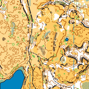
Featuring unique scabland terrain, Fishtrap Lake is challenging, yet accessible, and a complete joy to navigate. On one hand, there are tons of tiny cliffs and rock details. On the other hand, there are so few trees here, that the views are expansive, allowing you to orient yourself off of faraway cliffs. Fishtrap also provides a perfect opportunity to test compass skills, since there is little to stop you from beelining straight to the next control.
Read more on the map pageAccommodations
More to come
SAFETY & ETIQUETTE
Return to the Finish
All participants MUST return to the finish and download their e-punch or turn in their punch card.
Even if you have not finished your course, you must still return to the the finish and confirm with event staff that you have returned safely.
Out of Bounds
Some areas may be marked out of bounds. It is imperative to respect these boundaries to maintain our relationships with land managers. Participants MUST NOT go out of bounds. Any participant caught going out of bounds will be disqualified.
Course Closure
All participants MUST return to the finish by course closure time. If a participant does not return by course closure, event volunteers will begin coordinating a search party.
If you need a long time on the course, start as early in the start window as possible, wear a watch, and be prepared to cut your course short to make it back by the course closure time.
Whistle
All participants MUST carry a whistle on the course. Complimentary whistles are available at the start tent (please only take one).
If you are injured on the course and need assistance, blow three long blasts to call for help.
If you hear a call for help, abandon your course to find the person in distress.
Voices
Part of the fun and fairness of orienteering is navigating your own course, so please be polite when you find a checkpoint and don’t holler that you’ve found it.


