2025 Ultimate Orienteer #2 – Summit Trails (Score-O)
ULTIMATE ORIENTEER
Saturday, March 29 at Summit Trails/Rock Creek Natural Area in Maple Valley, WA
Meet Director: Ing Uhlin
 Event #2/8 in the Ultimate Orienteer Series!
An event with a mass start, each control on a Score-O course is worth a specified number of points. Generally, the more difficult controls (because of their navigational difficulty or distance from the start) are worth more points than easier controls. Competitors collect as many points as possible within a specified time limit. Point penalties are assessed for those returning after the time limit.
Careful course planning, keeping your eye on the clock, and staying located are all keys to success in Score-O. Even experts may have trouble visiting every control in the given time limit. Pick a route that best uses your time: maybe that means maximizing points in a short distance, or maybe you want to explore a new area and visit some controls along the way; it’s up to you!
COURSES
Course designer(s): Ben Cooper, Chris Cooper
| Course | Controls | Length | Climb |
| Beginner PtoP | 14 | 2.3 km | 25 m |
| Short Score-O | 23 | ||
| Long Score-O | 28 |
The map scale is 1:7,500 with 2.5 m contours.
What is my age class?
Score-O Course/Class Assignments for Ultimate points
If you want to earn Ultimate points, check the table below to see which category you should sign up for.
For example, if you’re a female 16 or under, your Ultimate age class is F-16 and, for this event, is assigned to the Short course. If you are up for a more challenging course, you can also earn points in F-18 or F-21+ on the Long course. Just keep in mind that other courses are more difficult, both navigationally and physically, and that you’ll be earning points only in the class you sign up for.
| Age Class | Course |
| • Female 16 and Under • Open 16 and Under |
Short |
| • Female 18 and Under • Open 18 and Under |
Long |
| • Female 50+ • Open 50+ |
Long |
| • Female 70+ • Open 70+ |
Long |
| • Female 20 and Under • Open 20 and Under |
Long |
| • Female 21+ • Open 21+ |
Long |
Other classes
If you don’t care about Ultimate points, sign up for a Rec category on the course of your choice.
COURSE NOTES
Course Notes
It is time to hit the trails and woods of Summit Trails once again! I know that most of you have run at Summit Trail numerous times over the past several years. But, how well do you really know the venue? Since this is an “Ultimate” race and not a “WIOL” race, you can expect controls in unfamiliar park terrain. Off trail control locations have been purposefully chosen not to duplicate any WIOL control locations.
This year’s score-O offers a 14-control, 2.3 km point to point beginner course. For the most part, the course sticks to the main trails and gains a mere 25 m of climb. The two score-o courses are a 23-control “short” course and a 28-control “long” course. Be careful when punching controls because not every control may be on your course. There are controls unique to each of the three different courses. The short and long have 60- and 75-minute time limits respectively.
As in year’s past, none of the courses’ controls are intentionally hidden. However, knowing which side of the feature the control is located will help determine your angle of approach. Knowing your control code symbols and evaluating the control location before you set out on your next leg will help reduce the amount of time you spend wandering around in the forest.
The November windstorm hit the Summit Trail forests with a heightened ferocity. All main trails have been cleared by the King County Parks Dept. However, the elk and deer have been less than proactive at clearing their trails. As such, there are quite a few trees down adjacent to or across the animal trails. As a compromise, the elk are currently working on developing new trails through the brush, but most have not fully formed.
The trails of Summit Trails are also used by equestrians. When encountering horses, please move to the side of the trail and call out to the riders. Make reasonable efforts not to spook the horses and announce your presence to riders as the horse approaches. Also, please do not cross the creek. Rock Creek is at full bank height right now and not safe to cross. There are no control or viable route options west of the creek so please remain on the creek’s east side.
Lastly, both deer and hiking trails within the Summit Trails venue are lined with blackberries and nettles. We strongly recommend pants and long-sleeved shirts. Please do not underestimate the amount of damage the vegetation can do to bare legs. Wear pants!!!
-Chris & Ben
Map Notes
Summit Trails Middle School is surrounded by over 300 acres of forest land dedicated to King County Parks after a history of railroad and logging use. The park area is known by many names depending on where in the complex you are: Danville-Georgetown Open Space, Rock Creek Natural Area, or Summit Trails Middle School private land. Over 14 miles of trails exist and are primarily used and upkept by The Backcountry Horsemen of Washington. Additionally, the area is home to herds of elk and deer, spotted owl and many other wildlife. It is highly likely you will encounter some of these while on the property. This past and present history has shaped the landscape in the park.
Much of the vegetation in the forest is thick with vegetation. However, due to the extensive elk and deer herd that call this area home, a vast network of elk trails exists and most have been accurately mapped within the last year. These elk paths are represented by white stripes on the map, meaning it is not a maintained trail, and subject to nature’s adjustment should it occur. Typically, very dense vegetation is flanked by runnable deer trail because the deer do just what a human would…avoid the dense stuff. This creates the beaten down wandering paths you see on the map. Since the herd is so prevalent, the animal paths are more robust than usual forest.
This area was logged in the not-too-distant past. As a result, many stumps were left behind to rot. There are thousands of them. Most of these stumps have degenerated into a half knoll, half stump concoction. In these situations, it is always mapped as a knoll. The only stumps mapped at Summit Trails are very large: at least 2 m in height and 1.5 m in width. These are undeniable stumps. On the map, these are marked with a brown X.
Rootstocks greater than 1m and visible from all directions are mapped with a brown triangle.
Flowing from south to north on the left side of the map is “Rock Creek”. This creek can be traversed anytime of year but does flow fast in winter and spring. However, there are certain places where there are logs that span across the creek and getting on and off the log on either side is quite easy. These are marked on the map with crossing point symbols. It is highly recommended you cross at these points should you find the need to cross the creek unless you don’t mind getting wet. There are other places where logs span the creek besides these points, however, either thick vegetation or dangerous approach on and off the log makes it undesirable. These difficult log crossings were not inserted on the map as crossing points.
There are a few linear contour features that can be useful when navigating off the trails in the park. Almost all of the hills are fairly straight. Often times this is coupled with good elk trails that can make for decent shortcuts if you have the courage. Careful though, because it is very easy to get lost in the dense vegetation and relocating becomes very difficult in these non-descript trails. Vegetation navigation is much more tricky than it might seem!
Lastly, it is recommended you wear pants! You will be presented with many off-trail checkpoints at this venue, testing your use of contours as handrails, compass for maintaining direction in flat areas, pace counting for distance estimation, and finding oneness with the elk as you bash through the brush.
– Timeless Words of Wisdom by John Brady
SCHEDULE
Tentative schedule (subject to change)
- 9:00-9:45 am – check-in
- 9:00-10:00 am – newcomer instruction
- 10:00 am – map handout, 75 min
- 10:05 am – course planning, 75 min
- 10:10 am – mass start, 75 min
- 10:15 am – map handout, 60 min
- 10:20 am – course planning, 60 min
- 10:25 am – mass start, 60 min
- 10:30-11:30 am – start window for the Beginner course
- 12:00 pm – courses close and all return to Finish
PRICES
Online pre-registration only!
$22 base price
– subtract $5 for CascadeOC members
– subtract $5 for using your own e-punch
Participating as a group? Just $5 for each additional adult (18+) group
member, no cost for additional minors.
What’s an e-punch?
An e-punch records your race. At each control, you’ll dip the e-punch into an electronic box, which will beep and flash as confirmation. After you finish, you’ll download the e-punch at the download tent and get a receipt that show which controls you visited and how long you took between each; these are your “splits.”
Part of the fun of orienteering is comparing your splits with people who completed the same course, and discussing the routes you took!
SIGN UP
LOCATION
PARKING
Parking on-site
CARPOOL
Looking for a carpool? Join the club email group and share your request to find a ride.
THE MAP
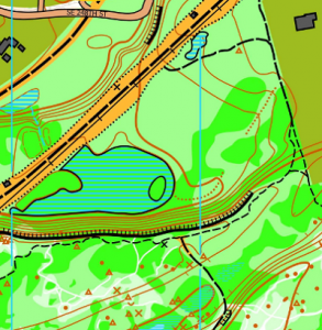
Summit Trails/Rock Creek Natural Area is part of the larger Danville-Georgetown Open Space. This moderately flat area has numerous contour and vegetation features, such as stumps, rootstocks, depressions, and knolls. Passage through the trees is often possible using faint elk trails. Adjacent to Summit Trail Middle School, which is generally the event center. Please note that no dogs are allowed on the campus of Summit Trails Middle School.
Read more on the map pageSAFETY & ETIQUETTE
Return to the Finish
All participants MUST return to the finish and download their e-punch or turn in their punch card.
Even if you have not finished your course, you must still return to the the finish and confirm with event staff that you have returned safely.
Out of Bounds
Some areas may be marked out of bounds. It is imperative to respect these boundaries to maintain our relationships with land managers. Participants MUST NOT go out of bounds. Any participant caught going out of bounds will be disqualified.
Course Closure
All participants MUST return to the finish by course closure time. If a participant does not return by course closure, event volunteers will begin coordinating a search party.
If you need a long time on the course, start as early in the start window as possible, wear a watch, and be prepared to cut your course short to make it back by the course closure time.
Whistle
All participants MUST carry a whistle on the course. Complimentary whistles are available at the start tent (please only take one).
If you are injured on the course and need assistance, blow three long blasts to call for help.
If you hear a call for help, abandon your course to find the person in distress.
Voices
Part of the fun and fairness of orienteering is navigating your own course, so please be polite when you find a checkpoint and don’t holler that you’ve found it.


