2021 Ultimate Orienteer #5 – Teanaway (Ultralong)
Everybody needs to fill out the COVID Assessment Form (every participant, group member, volunteer).
All group members (not the group leaders) need to sign the Group Member Waiver.
If you missed to sign up for a Start Time, check the list here and show up in time for an empty slot. Keep in mind that there is a one-mile hike to the Start location on Saturday.
Print your own Control Description sheet: https://cascadeoc.org/wp-conte
 Event #5/8 in the Ultimate Orienteer Series!
Teanaway Doubleheader – Part 1
Head east for another doubleheader! In this edition, we start with an Ultralong event at Teanaway Forks, then move to Jack Creek for a Middle!
- Saturday, June 12 – Teanaway Forks, Ultralong
- Sunday, June 13 – Jack Creek, Middle
COVID Operating Protocols
If you sign up for this event, you will be asked to read and agree to follow our COVID Operating Protocols. Our use permits are contingent on our ability to demonstrate that we can hold safe events, so we thank you in advance for helping us make this happen.
Complete the COVID Assessment Form.
Camping/Lodging
There’s free camping near Teanaway and a selection of hotels in Cle Elum.
Other things to do
See Discover Cle Elum for information about things to do in and near Cle Elum.
COURSES
Course designer(s): David Vaisar
Beginner – 2.4k, 7 controls, 40m climb
Intermediate – 4.7k, 11 controls, 130m climb
Short Advanced – 8.8k, 9 controls, 250m climb
Medium Advanced – 13.5k, 14 controls, 570m climb
Long Advanced – 18.1k, 26 controls, 725m climb
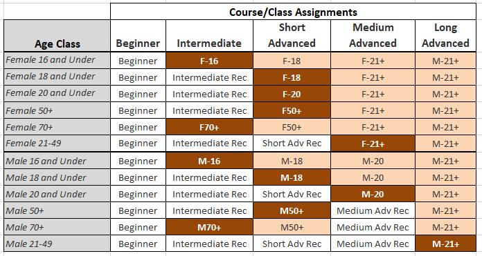
What is my age class?
Ultralong Course/Class Assignments for Ultimate points
If you want to earn Ultimate points, check the table below to see which category you should sign up for. Find your age class in the left column, then follow the row across to the right until you find the dark orange cell. That is your “assigned” category.
For example, if you’re a female 16 or under, your Ultimate age class is F-16 and, for this event, is assigned to the Intermediate course. If you are up for a more challenging course, you can also earn points in F-18 on the Short Advanced course, or F-21+ on the Medium Advanced course. Just keep in mind that other courses are more difficult, both navigationally and physically. Also keep in mind that you’ll be earning points only in the class you sign up for.
How are courses measured?
Courses are measured as the crow flies, in a direct line from control to control. Unless you have wings, you will travel farther than this distance! Courses are measured in kilometers, so a good rule of thumb is to simply round up to miles to estimate how far you will go. So in a 5 kilometer race, you’ll likely travel up to 5 miles.
COURSE NOTES
Safety bearing: go south until you reach the West Fork Teanaway River or the very large dirt road which parallels the river (West Fork Teanaway Road). Follow this east to the paved road.
Water
Following our COVID protocols, no water will be provided on the courses, so you must provide your own. Because the courses are ultralong and it can get hot in June at Teanaway, everyone is required to carry water on the course.
Start
The start for all courses is a 1.6k walk (20-30 minutes) from the parking/registration area. Make sure you plan your schedule accordingly. The route to the start will be marked with pin flags.
Finish
After you punch the finish, walk approximately 200 meters to the download (near registration/parking). Don’t forget to download.
Terrain and Map
- Vegetation and indistinct trails change rapidly on this map. Therefore it is very possible that what you might see on the course will be different than mapped, even with my minor updates.
- In general the terrain is very hilly, with large areas of pine forest in various stages of regrowth and harvest, with areas of thicker vine-maple-like vegetation in low points such as reentrants. I have given opportunities to travel through the various types of terrain that can be found here.
- Some areas of cut down or fallen trees can make walking or running pace travel slower though not impossible. These are mapped either as various degrees of undergrowth or as scattered trees with light green or darker green dots.
*Important: recent path/trail clearing has left thick woody debris on sides of some paths thus making vegetation directly along these seem thicker
*A brown dot in a circle is logging debris pile, these can come in many forms: they can be in various stages of decay, and/or be burned, and might not be a real distinct pile. On the control description sheet they are designated as a special object O.
* On the map a green x is a distinct tree
Specific notes for courses
In designing these courses I have guided myself along the OUSA definition of an ultralong event: “EMPHASIS: Endurance, route choice, and rough map reading” (Rules for OUSA Sanctioning Events March, 2018). I have also attempted to minimize non-optional travel through very thick vegetation.
*Note: for Long and Medium Advanced: An area in the west part of the map has burned recently (2017) and the map has not been updated to reflect this. This will be indicated on map.
— David Vaisar
SCHEDULE
Pre-registration only!
9:30am-12:30pm – Starts (start times are pre-assigned; sign up for a start time before Thursday at 9pm; if you don’t, we’ll pick one for you)
3:00pm – Courses close*
*Wear a watch to ensure that you return to the finish by course closure time, even if you have to abandon your course to do so. Those returning after course closure will be disqualified and will make the volunteer staff very grumpy.
Why is there a start window?
This event uses an interval start, which means that participants are started in waves instead of all at once. When you arrive at the start tent, find the chute for your course and follow the start volunteer’s instructions.
PRICES
Pre-registration is required
$8 – Cascade OC members*
$13 – non-members*
*Add $5 to rent an epunch stick
Want to buy your own epunch stick?
While we do offer rentals, we encourage everyone to purchase their own epunch stick. If you’d like to take the plunge, the nearest supplier is SPORTident.us in California. We recommend purchasing either SI-9 , SI-10, or Air+ sticks. Other vendors can be found here.
What’s an e-punch?
An e-punch records your race. At each control, you’ll dip the e-punch into an electronic box, which will beep and flash as confirmation. After you finish, you’ll download the e-punch at the download tent and get a receipt that show which controls you visited and how long you took between each; these are your “splits.”
Part of the fun of orienteering is comparing your splits with people who completed the same course, and discussing the routes you took!
SIGN UP
LOCATION
PARKING
Discover Pass Required
There is ample parking near the event center. This venue is part of the Teanaway Community Forest and you will need a Discover Pass to park. You can purchase a Discover Pass (annual or one-day) online or in person at many hunting/fishing license vendors or at several retail locations. Check the Discover Pass website for details.
CARPOOL
Looking for a carpool? Join the Google club group list and share your request to find a ride.
THE MAP
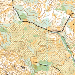
Part of a chain of orienteering maps in the Teanaway Community Forest, Teanaway Forks (or “Teanaway Valley”) is rugged, challenging, and beautiful. There is a fair amount of contour details and lots of open pine forest and grassland. However, vegetation becomes quickly outdated here, so do not rely on vegetation alone; contours are your best friend!
New orienteers should consider choosing a shorter or easier course than usual.
Teanaway Forks is rugged and moderately hilly, with some especially steep areas that nice course designers try to avoid. Deadfall on the ground makes running or hiking more strenuous.
Read more on the map pageSAFETY & ETIQUETTE
Return to the Finish
All participants MUST return to the finish and download their e-punch or turn in their punch card.
Even if you have not finished your course, you must still return to the the finish and confirm with event staff that you have returned safely.
Out of Bounds
Some areas may be marked out of bounds. It is imperative to respect these boundaries to maintain our relationships with land managers. Participants MUST NOT go out of bounds. Any participant caught going out of bounds will be disqualified.
Course Closure
All participants MUST return to the finish by course closure time. If a participant does not return by course closure, event volunteers will begin coordinating a search party.
If you need a long time on the course, start as early in the start window as possible, wear a watch, and be prepared to cut your course short to make it back by the course closure time.
Whistle
All participants MUST carry a whistle on the course. Complimentary whistles are available at the start tent (please only take one).
If you are injured on the course and need assistance, blow three long blasts to call for help.
If you hear a call for help, abandon your course to find the person in distress.
Voices
Part of the fun and fairness of orienteering is navigating your own course, so please be polite when you find a checkpoint and don’t holler that you’ve found it.


