Winter Series / WIOL #3
WINTER SERIESWINTER LEAGUE
Saturday, December 3 at Shoreview Park/Shoreline CC in Shoreline, WA
Welcome to the Winter and School League (WIOL) Series!
ABOUT THE SERIES
These concurrent and popular series run from November through February. The Winter Series is open to all, while WIOL (Winter Interscholastic Orienteering League) is designed for students from Elementary-age through High School.
Events in the first half of the season are held in beginner-friendly venues, some of which are trails-only, while events in the second half move to more forested and challenging venues. The season is capped off with a championship event and an awards ceremony to recognize top participants and school teams in both the series overall and championship event.
As with all of CascadeOC’s series events, while it is fun to participate in the entire series, it is not required. Each event is a stand-alone event and open to all!
- Registration for the SCHOOL LEAGUE is done through paper forms. For more information, visit the School League (WIOL) page.
- Registration for WINTER SERIES (open to both kids and adults), can be done at the link below or at the event!
COURSES
Course designer(s): Patrick Nuss
| Course | Controls | Length | Climb |
|---|---|---|---|
| Beginner/Elementary | 9 | 1.1 km | 50 m |
| Middle School | 9 | 1.6 km | 55 m |
| Intermediate/JV Girls | 12 | 2.5 km | 85 m |
| JV Boys North | 12 | 2.5 km | 85 m |
| JV Boys South | 12 | 2.5 km | 85 m |
| Varsity | 17 | 4.1 km | 155 m |
| Short Advanced | 18 | 3.9 km | 145 m |
| Long Advanced | 25 | 5.3 km | 290 m |
How are courses measured?
Courses are measured as the crow flies, in a direct line from control to control. Unless you have wings, you will travel farther than this distance! Courses are measured in kilometers, so a good rule of thumb is to simply round up to miles to estimate how far you will go. So in a 5 kilometer race, you’ll likely travel up to 5 miles.
MAP & COURSE NOTES
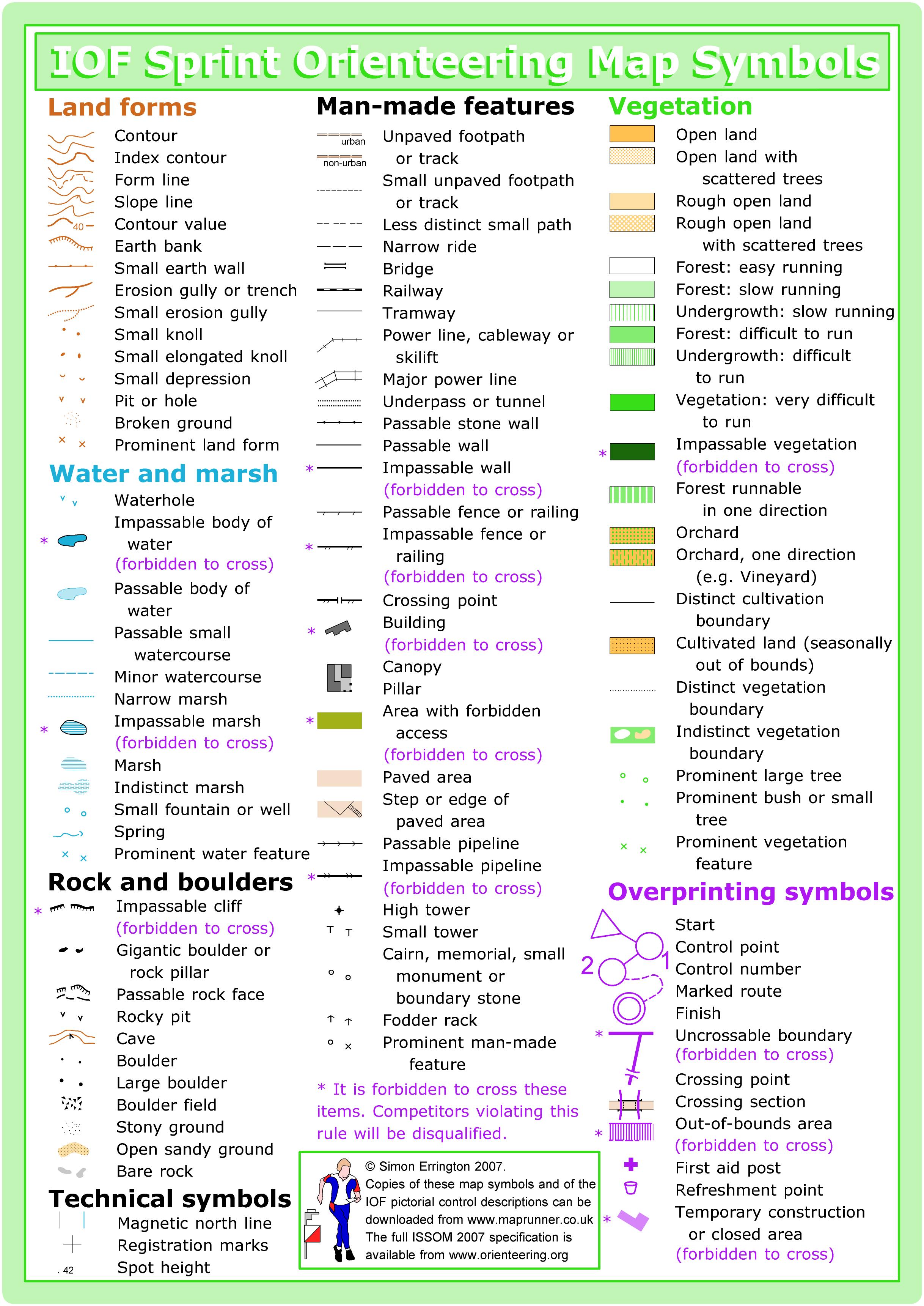
This area was newly remapped in 2015 to the sprint orienteering international standard, which is optimized for complex urban terrain and has specific symbols for uncrossable features like tall walls and high fences. It’s also wise to study up on buildings, canopies, and passageway symbols. Here’s a quickie guide.
The map is printed at 1:5000 scale and features a variety of terrains: wooded trails, ball fields & play areas, and a complex college campus. Intermediate, JV, Varsity, and both Advanced courses will experience the full variety!
This map was made in summer 2015, which means that the vegetation in winter can be substantially thinner in places. There are also several instances of tiny spur trails off the main trails. These are typically not mapped, as they come and go.
Crossable fences on this map are indeed crossable. In most cases they are railings along sidewalks and covered walkways.
Make sure to verify checkpoint codes! There are 49 control flags out there, some as close together as 30 meters. 21 of those control flags are on the main campus, which is approximately 400m x 250m.
The Varsity and Short Advanced courses will each visit one checkpoint twice.
The Varsity, Short Advanced, and Long Advanced courses may encounter some “No Trespassing” signs on the trails northeast of campus. You can orienteer here; the signs are to deter homeless campsites.
SCHEDULE
9:30am – Registration opens & Newcomer instruction available
10:00am – Start opens
11:00am – Newcomer instruction ends
11:30am – Registration closes
Noon – Start closes
3:00pm – Course closes
Why is there a start window?
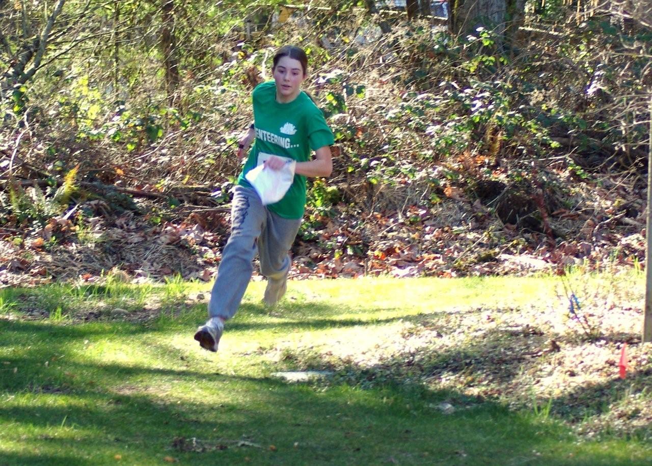
This event uses an interval start, which means that participants are started in waves instead of all at once. When you arrive at the start tent, find the chute for your course and follow the start volunteer’s instructions.
Those participating in School League (WIOL) will be provided a specific start time, and should show up at the tent several minutes before their designated time.
PRICES
PRE-REGISTRATION PRICES
$17 base price
– subtract $5 for CascadeOC members
– subtract $5 for using your own e-punch
DAY-OF-EVENT REGISTRATION
$20 base price
– subtract $5 for CascadeOC members
– subtract $5 for using your own e-punch
SCHOOL LEAGUE (WIOL)
Registration for the School League is done through paper forms. For more information, visit the School League (WIOL) page.
What’s an e-punch?
An e-punch records your race. At each control, you’ll dip the e-punch into an electronic box, which will beep and flash as confirmation. After you finish, you’ll download the e-punch at the download tent and get a receipt that show which controls you visited and how long you took between each; these are your “splits.”
Part of the fun of orienteering is comparing your splits with people who completed the same course, and discussing the routes you took!
SIGN UP
Online pre-registration closes: 9pm, Thursday, December 1
Day-of-event registration is available by cash or check, made payable to Cascade Orienteering Club
Registration for School League (WIOL) is done via paper forms. See the School League page for more information.
LOCATION
PARKING
Parking will be at the north end of Shoreline Community College, and NOT in Shoreview Park.
We will have a similar setup to the last Winter Series & School League event held here in January 2015. The tents for registration, check-in, and finish will be on the northwest side of the 2500 building, just off the parking lot. The start tents will be on the northeast side of the track.
From Innis Arden Way, follow the signs to the Off-Leash Dog Park. Drive through the campus parking lots to the entrance to the Dog Park. Turn right (left goes to the Dog Park), to the parking lot by the 2500 building.
CARPOOL
Looking for a carpool? Join the Yahoo listserv and share your request to find a ride.
THE MAP
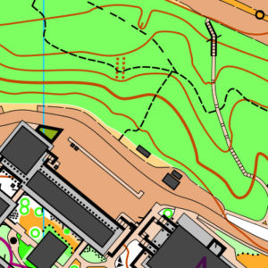
This map is like two venues in one: the hilly and wooded Shoreview Park and the complex campus of Shoreline Community College. Be prepared to switch mental gears as you move between the two!
This venue is mapped to sprint standard (or ISSOM, the International Specification for Sprint Orienteering Maps). The sprint standard has a few key differences from traditional orienteering maps (or ISOM, the International Specification for Orienteering Maps):
- Some features (usually walls) can be marked as uncrossable (illegal to cross)
- Out-of-bounds is represented by olive green, which is used often for flower beds or private areas
- Footpaths and paved areas appear tan
- There are additional urban symbols, including canopies, which illustrate covered passageways
Read more on the map page
SAFETY & ETIQUETTE
Return to the Finish
All participants MUST return to the finish and download their e-punch or turn in their punch card.
Even if you have not finished your course, you must still return to the the finish and confirm with event staff that you have returned safely.
Out of Bounds
Some areas may be marked out of bounds. It is imperative to respect these boundaries to maintain our relationships with land managers. Participants MUST NOT go out of bounds. Any participant caught going out of bounds will be disqualified.
Course Closure
All participants MUST return to the finish by course closure time. If a participant does not return by course closure, event volunteers will begin coordinating a search party.
If you need a long time on the course, start as early in the start window as possible, wear a watch, and be prepared to cut your course short to make it back by the course closure time.
Whistle
All participants MUST carry a whistle on the course. Complimentary whistles are available at the start tent (please only take one).
If you are injured on the course and need assistance, blow three long blasts to call for help.
If you hear a call for help, abandon your course to find the person in distress.
Voices
Part of the fun and fairness of orienteering is navigating your own course, so please be polite when you find a checkpoint and don’t holler that you’ve found it.


