2021 Wednesday Evening #2 – Big Finn Hill Park
WEDNESDAY EVENING
Wednesday, July 28 at Big Finn Hill – parking at Finn Hill in Kirkland, WA
Meet Director: Will Enger
The second event in the 2021 Wednesday Evening Series will be held at Big Finn Hill Park, in Kirkland. The Wednesday Evening Series is our most relaxed, casual set of navigation events, held in local parks once the weather warms up. These events are a little more low-key than those in the Winter League, and we typically offer a barbeque afterward for all participants.
Events in the Wednesday Evening Series are generally less challenging (both physically and navigationally) than many of our other events, and are therefore great for beginners and those less experienced with orienteering – while also offering a challenge to longtime participants of the sport.
We will be offering the usual post-race fare, with the familiar precautions – please practice social distancing, avoid congregating in large groups, and wear a mask when around others. Thank you!
COURSES
Course designer(s): Cynthia Bartok, Jon Olson
|
Course |
Controls |
Length (km) |
Climb (m) |
|
1 |
8 |
1.2 |
25 |
|
2 |
8 |
2.0 |
55 |
|
3 |
12 |
3.1 |
95 |
|
4 |
17 |
4.9 |
155 |
How are courses measured?
Courses are measured as the crow flies, in a direct line from control to control. Unless you have wings, you will travel farther than this distance! Courses are measured in kilometers, so a good rule of thumb is to simply round up to miles to estimate how far you will go. So in a 5 kilometer race, you’ll likely travel up to 5 miles.
COURSE NOTES
SCHEDULE
5:00 pm – Registration and starts open.
7:00 pm – Registration and starts close.
8:00 pm – Course closure.
Why is there a start window?
This event uses an interval start, which means that participants are started in waves instead of all at once. When you arrive at the start tent, find the chute for your course and follow the start volunteer’s instructions.
PRICES
PRE-REGISTRATION PRICES
$17 base price
– subtract $5 for CascadeOC members
– subtract $5 for using your own e-punch
DAY-OF-EVENT REGISTRATION
$20 base price
– subtract $5 for CascadeOC members
– subtract $5 for using your own e-punch
What’s an e-punch?
An e-punch records your race. At each control, you’ll dip the e-punch into an electronic box, which will beep and flash as confirmation. After you finish, you’ll download the e-punch at the download tent and get a receipt that show which controls you visited and how long you took between each; these are your “splits.”
Part of the fun of orienteering is comparing your splits with people who completed the same course, and discussing the routes you took!
SIGN UP
Online pre-registration closes: 7/27/2021
Day-of-event registration is available by cash or check, made payable to Cascade Orienteering Club
LOCATION
PARKING
Parking will be located in the lot accessed from Juanita Drive via NE 138th Street.
CARPOOL
Looking for a carpool? Join the Yahoo listserv and share your request to find a ride.
THE MAP
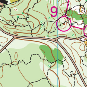
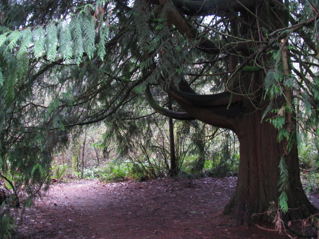
There are delights here for beginners and advanced orienteers alike. Buildings, ballfields, and trails provide a great beginner and intermediate area, while the forest is a giant knot of trails that can terrorize any advanced orienteer who becomes lazy about reading contours or using their compass to check the direction of the trail.
Read more on the map pageSAFETY & ETIQUETTE
Return to the Finish
All participants MUST return to the finish and download their e-punch or turn in their punch card.
Even if you have not finished your course, you must still return to the the finish and confirm with event staff that you have returned safely.
Out of Bounds
Some areas may be marked out of bounds. It is imperative to respect these boundaries to maintain our relationships with land managers. Participants MUST NOT go out of bounds. Any participant caught going out of bounds will be disqualified.
Course Closure
All participants MUST return to the finish by course closure time. If a participant does not return by course closure, event volunteers will begin coordinating a search party.
If you need a long time on the course, start as early in the start window as possible, wear a watch, and be prepared to cut your course short to make it back by the course closure time.
Whistle
All participants MUST carry a whistle on the course. Complimentary whistles are available at the start tent (please only take one).
If you are injured on the course and need assistance, blow three long blasts to call for help.
If you hear a call for help, abandon your course to find the person in distress.
Voices
Part of the fun and fairness of orienteering is navigating your own course, so please be polite when you find a checkpoint and don’t holler that you’ve found it.


