2021-22 Winter League #1 – Magnuson Park
WINTER LEAGUE
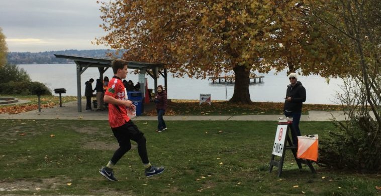
Saturday, November 6 at Magnuson Park in Seattle, WA
The 2021-22 Winter League Series Rules and Information have changed due to COVID. Please read all the important information for the Public Procedures/Rules here and for the WIOL Procedures/Rules here.
**THERE IS NO DAY OF MEET REGISTRATION**
Pre-Registration Closes 11/3 at 9pm
Magnuson Meet Documents:
Winter League is the Pacific Northwest’s premier competitive orienteering series for all ages.
- Elementary, Middle School, High School and College students compete under the banner of the Washington Interscholastic Orienteering League (WIOL).
- Winter League public courses offer a range of categories from a competitive long advanced category to non-competitive beginner-friendly categories at every event!
COURSES
Course designer(s): Ethan O'Conner & Shannon Cheng
WIOL Courses:
| Controls | Length | Climb | |
| Elementary | 10 | 1.2 km | 15 m |
| Middle School | 12 | 1.6 km | 25 m |
| High School JV Rookie | 11 | 2.0 km | 30 m |
| High School JV Female | 12 | 2.4 km | 25 m |
| High School JV Male | 13 | 2.5 km | 30 m |
| High School Varsity | 13 | 3.3 km | 40 m |
| Intercollegiate JV | 13 | 2.5 km | 30 m |
| Intercollegiate Varsity | 20 | 5.8 km | 100 m |
Public Courses:
| Controls | Length | Climb | |
| Beginner | 10 | 1.2 km | 15 m |
| Advanced Beginner | 11 | 2.0 km | 30 m |
| Intermediate | 12 | 2.4 km | 25 m |
| Short Advanced | 14 | 3.4 km | 55 m |
| Long Advanced | 20 | 5.8 km | 100 m |
How are courses measured?
Courses are measured as the crow flies, in a direct line from control to control. Unless you have wings, you will travel farther than this distance! Courses are measured in kilometers, so a good rule of thumb is to simply round up to miles to estimate how far you will go. So in a 5 kilometer race, you’ll likely travel up to 5 miles.
COURSE NOTES
Welcome to Winter League 2021-22!
Magnuson Park in early November can be beautiful and dry or beautiful and soggy beyond belief. Be prepared for possible wet conditions. We hope you enjoy exploring everything the mostly flat park has to offer — from grassy lakeside promenades to twisty-turny forest singletrack to a complex web of trails and vegetation in open, wild fields.
Notes:
· Many of the courses traverse a shallow ditch full of apples near the start. Please don’t roll an ankle or fall while you’re getting your head into the map.
· Blackberries: They are nasty and somewhat widespread; dress accordingly and watch out if you venture off-trail. Courses have been designed so travel through blackberries shouldn’t be necessary, but be aware.
· Deadfall: Recent windstorms have left many downed trees and branches throughout the park. If you encounter a fallen tree on a mapped trail you may need to poke around for a way through.
· Road safety: Some courses may cross active roads and parking lots – please cross carefully. If you follow a road, use trails or the shoulder to stay out of the way of traffic.
· Map notes: Area mapped as rough open land (tan / light orange) ranges from unmowed grass to bumpy, pitted land with tufts of vegetation. Dark orange is reserved for mowed/manicured grassy areas.
· Forbidden routes & out of bounds areas: Two trails in the south-central part of the map are marked as forbidden routes with purple Xs – these trails are closed by the park and are not to be used. They were taped off when the designers last visited, but don’t depend on the tape being there for navigation. Violating out of bounds or forbidden route markings is disqualifying and threatens our ability to use Magnuson Park for future events.
· New plantings / Ecologically sensitive areas: Revegetation is an ongoing effort in Magnuson Park. Large new plantings have been marked out of bounds on the map. Outside of these areas, if you encounter fresh mulch, plants with ribbons / flagging, or other signs of recent planting, consider going around. At the very least use caution to avoid trampling plants and eroding freshly worked ground. The same applies to marshy areas and other areas prone to erosion.
· PS: A line completely across the park is kept clear of vegetation to allow one to see all the way from one side to the other – more than 1060 meters. See if you can find this feature on your map – and guess why someone went to the effort of cutting trenches in hills to make this possible!
SCHEDULE
**Due to COVID – ALL Public and WIOL participants will have assigned start times**
9:45 am – Assigned starts begin
12:45 pm – Last possible assigned start time
2:30 pm – Course closes
PRICES
PUBLIC COURSE PRE-REGISTRATION PRICES
$22 base price
– subtract $5 for CascadeOC members
– subtract $5 for using your own e-punch
Become a member here.
**Due to COVID, there will be no day of meet onsite registration for Winter League 2021-22.**
What’s an e-punch?
An e-punch records your race. At each control, you’ll dip the e-punch into an electronic box, which will beep and flash as confirmation. After you finish, you’ll download the e-punch at the download tent and get a receipt that show which controls you visited and how long you took between each; these are your “splits.”
Part of the fun of orienteering is comparing your splits with people who completed the same course, and discussing the routes you took!
SIGN UP
Online pre-registration RSVP dates:
- The deadline for Meet Registration for public that wants to request a start time is Tuesday pre-meet at Noon.
- The deadline for Meet Registration for public not requesting a specific start time is Wednesday pre-meet at 9pm.
- Friday evening pre-meet at 7pm all COVID attestation forms are due.
LOCATION
PARKING
Follow the Cascade OC directional signs to the E-4 parking lot. See the site map here.
THE MAP
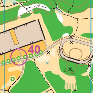
As a large (1:10,000-scale), open venue with profusely scattered vegetation, Magnuson Park is often an early-season school league venue. Rather than a collection of areas with different personality, this is a single and diverse collection of grassland, dark green, trails, roads, and water areas, with one notable large hill.
Event parking is usually in the northernmost parking lot along with water, for easiest access to the shelter and restrooms.
Read more on the map pageSAFETY & ETIQUETTE
Return to the Finish
All participants MUST return to the finish and download their e-punch or turn in their punch card.
Even if you have not finished your course, you must still return to the the finish and confirm with event staff that you have returned safely.
Out of Bounds
Some areas may be marked out of bounds. It is imperative to respect these boundaries to maintain our relationships with land managers. Participants MUST NOT go out of bounds. Any participant caught going out of bounds will be disqualified.
Course Closure
All participants MUST return to the finish by course closure time. If a participant does not return by course closure, event volunteers will begin coordinating a search party.
If you need a long time on the course, start as early in the start window as possible, wear a watch, and be prepared to cut your course short to make it back by the course closure time.
Whistle
All participants MUST carry a whistle on the course. Complimentary whistles are available at the start tent (please only take one).
If you are injured on the course and need assistance, blow three long blasts to call for help.
If you hear a call for help, abandon your course to find the person in distress.
Voices
Part of the fun and fairness of orienteering is navigating your own course, so please be polite when you find a checkpoint and don’t holler that you’ve found it.


