Details for event can be found here:
COURSES
Course designer(s):
SCHEDULE
PRICES
Free. RSVP Required. See event page here:
SIGN UP
LOCATION
THE MAP
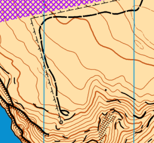
The Frenchman Spring map is owned and maintained by Forest Runs. They have generously allowed us to use it for some of our events.
Frenchman Spring contains a lot of rocky features. A number of decisions have been made about what and how to map.
- International Specifications for Orienteering Maps 2017 symbols are used.
- Vegetation is mapped in a limited fashion:
- The only vegetation that limits running in any way is sage bush – still growing or burnt leftovers – and similar semi-desert plants. They are mapped with green vertical stripes – undergrowth, slower running symbol – in locations where the impact is larger.
- There are several more distinct trees mapped with the green dot symbol.
- In general, only distinct objects are mapped. A 1-meter-high boulder is mapped if it is in a gravelly area, but not if it lies between other larger boulders. In a similar fashion, we don’t mark 209 Boulder field or 210 Stony ground in a context where these make the map too hard to read. In contrast, most of the 418 Prominent bush or tree are prominent only in the Frenchman Spring context.
- Uncrossable cliff usually means very uncrossable. Please respect that and do not go too close to it.
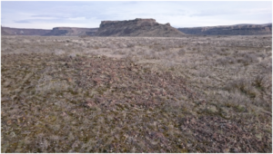
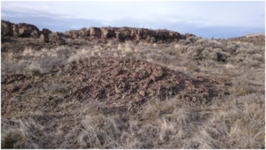
- Ground covered with little to no vegetation while still allowing near full speed running is mapped as 214 Bare rock. Unlike in many other venues, bare rock in Frenchman Spring is not necessarily a smooth cliff face but may instead resemble a pile of rocks. For instance, in the photo below, the foreground is mapped as “bare rock.”
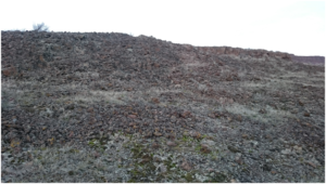
- Rocky ground may be similar to bare rock, just less smooth and making running slower. Below is a few meters high hillside, mapped as 210 Stony ground, slow running
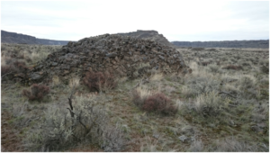
- As basalt breaks into fragments of widely different sizes over time, so most of the boulders are in some sense just piles of rocks. This is a 1-meter-high rocky thing, mapped as 204 Boulder
- Similar objects that look less rocky may be mapped as knolls. The one in the following photo is 109 Small knoll
Read more on the map page


