This is a double header weekend Sept 28-29 on Peteris Ledins’s maps around the Twenty-nine Pines Campground on Teanaway Rd N Fork.
Saturday: Middle distance, courses north of Jack Creek (east of Teanaway Rd N Fork)
Sunday: Long distance, courses south of Jungle Creek (west of 29 Pines Campground).
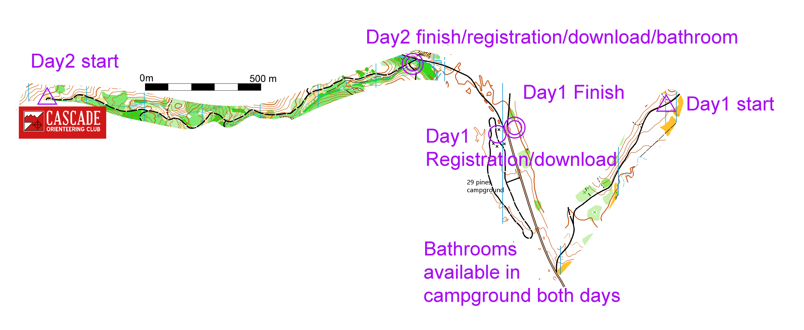
On Saturday, Registration will be at the 29 Pines Campground. On Sunday, Registration will be by the Finish for Day 2. (See staging map)
Beginner instruction with mini-course on Saturday 11:00 am, by Registration at 29 Pines Campground.
There will be an assigned start list for the M21+ and F21+ classes on Day 1. This is in preparation for our club’s participation as start organizers in NAOC 2020.
There may be hunting in the area. Please wear orange and bright clothing to attract the attention of hunters.
We are trying to go “Low Waste” so please bring your own container (cup, bottle, bladder) for the water stations.
Note – The Blue course has 37 controls and you need a high-capacity epunch stick. You can borrow one when you check in if you don’t have your own.
For questions, contact Peteris Ledins.
COURSES
Course designer(s): Peteris Ledins, Ott Toomet
There will be seven courses each day; White, Yellow, Orange, Brown, Green, Red, and Blue. Course details will be provided here once the courses are finalized.
To learn more about the color system for courses, go to
https://orienteeringusa.org/new-o/select-course
and for course and class structures, go to
https://orienteeringusa.org/orienteers/on-foot/events/sanctioned-events-calendar
(ignore the distances in the table).
Points will be given each day to the participants on the courses corresponding to their age and gender, and those “running up”. For example, a 50-year old male can be ranked running in class M50-54 or any other class up to the M21+ class. The appropriate class is based on your age on Dec 31, 2019. Overall winners in the competitive classes are based on the points for the two days. Classes with fewer than three runners may be combined at the discretion of the organizers. There are Open classes on all courses; they are open to all age and genders, solo participants or groups, and they are not competitive.
You can sign up for any course that you think you can manage, but you may not be part of the ranking. If you are registering for a course that has lower difficulty than your age/gender class, please register for the Open class on the course. We encourage first-timers to sign up for the White, Yellow, or Orange courses.
In addition to these competitive classes, there is an Open class on all courses, open to solo and groups.
F: Female, M: Male. A dash (“-“) before an age indicates no age limit up to that age. A plus (“+”) after an age indicates no age limit above that age. The “21” and Open classes don’t have any age limits.
| Classes for points | Courses | Navigational difficulty |
| F-10/F-12/M-10/M-12 | White | Beginner |
| F-14/M-14 | Yellow | Advanced beginner |
| F-16/M-16 | Orange | Intermediate |
| F-18/F55+*/M65+* | Brown | Advanced |
| F-20/F35-54*/M-18/M50-64* | Green | Advanced |
| F-21+/M-20/M35-49* | Red | Advanced |
| M-21+ | Blue | Advanced |
* In 5-year age groups.
How are courses measured?
Courses are measured as the crow flies, in a direct line from control to control. Unless you have wings, you will travel farther than this distance! Courses are measured in kilometers, so a good rule of thumb is to simply round up to miles to estimate how far you will go. So in a 5 kilometer race, you’ll likely travel up to 5 miles.
COURSE NOTES
Safety: All participants must carry a whistle on the courses.
Teanaway Cup takes place around Teanaway North Fork river, near the 29 Pines campground (free but Discover pass needed). All starts and finishes are from walking distance (but rather long) from the campground. Finish is relatively closer to the campground.
The venue is mostly forested where the vegetation ranges between open pine forests to dense thickets of vine maple and salal. The area is hilly and a long walk to start is needed to avoid too much climb on the course. The forest has burned two years ago and made the terrain in most cases more accessible. The forest has thorny underbrush in places; we recommend long pants and shin guards.
All courses have remote start: follow flagged route from the map issue point (start punch) to the start triangle (just flag, no punch there). Note: you have to follow the marked route to the start triangle flag, free route choice begins thereafter.
For successful navigation on all courses, except White, you should understand landforms and how these are represented on the map with contours. In particular, you should know what are re-entrants and spurs, how these are represented on the map and on the control description.
There are free-range cattle in the forest (and occasionally on roads!). Please be careful and try not to disturb them!
Day 1
Safety bearing: go west, down the hill, to the main road (North Fork Teanaway road).
Maximum time on course is 2 hours. You have to return to the finish after 2 hours from your start punch, even if you haven’t completed the course, and even if the course is not closed yet.
Map: The map for Day 1, Jack Creek North, is a completely new although small area. It covers a hillside that is rather flat and open near the campground at its western edge, and a lot of interesting landforms elsewhere. The lower part of the landscape is mostly open forest and wide open areas, elsewhere it ranges between open forest on spurs to dense vegetation in narrow valleys. The orienteers can encounter a few trails and a single forest road. It uses the ISOM 2017 symbol set with 1:10,000 scale and 5-meter contours.
Special Symbols: Green X is used most often for rootstocks, but also for stumps and logging debris piles. Green O is used for distinct trees.
Terrain and Vegetation: The map has fast and open meadows mixed with some open forest on a terrace near the main road, steeper slopes with some open runnable forest, and some less runnable terrain.
Courses: The courses are White-Blue Middle-distance courses according to OUSA guidelines. There is a marked route between two consecutive controls on the Beginner (White) course. Follow the tape, marked as a red dashed line on the map. The Advanced courses will have plenty of climb mixed with fast running in the flat part of the map. There is no water on the courses but there is water at the Finish.
Starts: The Starts are remote. Day 1 has a hike-in of 1.3 km (about 15 min walk) from the exit of the campground. The M21+ and F21+ classes will possibly have assigned start times with no start punch. Please check back on the event page for updated information. All starts will be run-in starts to the start triangle that will have a control but no punch. See the route to Start here.
Finish: The Finish is located on the east side of the paved turnaround near 29 Pines campground.
Day 2
Safety bearing: Go south in the Northern part of the map; go east in the Southern part of the map. Follow roads to finish.
Large swaths of the forest burned two years ago. Many stumps have completely burned out leaving large holes in place of roots. Be careful!
Maximum time on course is 3 hours. You have to return to the finish after 2 hours from your start punch, even if you haven’t completed the course, and even if the course is not closed yet.
Map: The map for Day 2, Jungle Creek is in most part the one used in Fall 2016, but it is somewhat extended to north-west, and updated because of the forest fires. In particular, a large number of dense brush, rootstocks, stumps, and fallen logs have burned away in places. The terrain offers a lot of different landforms from large open hilltops to partly overgrown depressions. The vegetation ranges between open forest to dense (dark green) brush, the latter is often in wetter areas but not exclusively so. The scale is 10,000 and the contours 5 meters.
Special Symbols: Green X is used for rootstocks or logging debris piles. Green O is used for a distinct tree or large stump/snag. A green filled circle is a small bush. A Ride symbol is used for various older roads that are sometimes overgrown and sometimes hard to follow.
Ugly undergrowth (happens sometimes) – in some cases salal (or similar) is obstructing the way. When it is nearly impossible to cross, the darkest green color is used. Undergrowth symbols are used when salal is close, or when need to run around salal. Usually navigation around is possible.
Courses: There are marked routes between some consecutive controls on Beginner (White) and Yellow courses. Follow the tape, marked as a red dashed line on the map. The rest of the courses will have a middle feel to it – there will be some longer legs, but the Long will have a Middle feel to it; the courses are designed to maximize the control count. There are many controls on the map. Check the control codes and make sure you punch the correct one.
Water: The Green, Red, and Blue courses have 2 water locations. Brown and Orange have one water station. Orange and Yellow courses have water in a checkpoint close to finish. White has water available at finish only.
Starts: Start is roughly 30 minute walk from the campground (and largely uphill). The Starts are remote. Day 2 has a hike-in of about 2 km from the exit of the campground. See the route to Start here.
Finish: The Finish is located about 0.5 km northwest along the road from the campground.
Course details:
Day 1
| Courses | Controls | Distance | Climb | Expected winning time (min) |
| White | 9 | 1.6 km | 20 m | 35 |
| Yellow | 14 | 2.7 km | 65 m | 35 |
| Orange | 13 | 3.1 km | 80 m | 35 |
| Brown | 17 | 3.5 km | 80 m | 35 |
| Green | 15 | 3.4 km | 125 m | 35 |
| Red | 16 | 4.4 km | 160 m | 35 |
| Blue | 21 | 5.3 km | 200 m | 37 |
Day 2
| Courses | Controls | Distance | Climb | Expected winning time (min) |
| White | 6 | 2.2 km | 10 m | – |
| Yellow | 10 | 3.0 km | 35 m | – |
| Orange | 14 | 3.5 km | 55 m | – |
| Brown | 12 | 3.3 km | 65 m | 50 |
| Green | 16 | 5.1 km | 150 m | 60 |
| Red | 26 | 6.6 km | 195 m | 80 |
| Blue | 37 | 9.0 km | 265 m | 90 |
SCHEDULE
Day 1 Saturday:
Registration open 11:00 am – 12:30 pm
Start window: 12:00 pm – 1:30 pm
Beginner instruction with mini-course: 11:00 am
Newcomer instruction: 11:30 am – 12:30 pm
Max time on course: 2 hours. All participants have to return after the max time on course.
There is a 1-km walk to Start.
Day 2 Sunday:
Registration open 8:30 am – 9:30 am
Start window: 9:30 am – 11:00 am
Course closure: 2:00 pm. All participants have to return by the course closure.
Newcomer instruction: 8:30 am – 9:30 am
Max time on course: 3 hours. All participants have to return after the max time on course.
There is a 2-km walk to Start.
Why is there a start window?
This event uses an interval start, which means that participants are started in waves instead of all at once. When you arrive at the start tent, find the chute for your course and follow the start volunteer’s instructions.
PRICES
PRE-REGISTRATION PRICES
$17 base price
– subtract $5 for CascadeOC members
– subtract $5 for using your own e-punch
DAY-OF-EVENT REGISTRATION
$20 base price
– subtract $5 for CascadeOC members
– subtract $5 for using your own e-punch
What’s an e-punch?
An e-punch records your race. At each control, you’ll dip the e-punch into an electronic box, which will beep and flash as confirmation. After you finish, you’ll download the e-punch at the download tent and get a receipt that show which controls you visited and how long you took between each; these are your “splits.”
Part of the fun of orienteering is comparing your splits with people who completed the same course, and discussing the routes you took!
SIGN UP
Please pre-register so we know how many maps to print. A limited number of maps will be available for registration at the events. Day-of-event registration is available by cash or check, made payable to Cascade Orienteering Club.
LOCATION
CARPOOL
Looking for a carpool? Join the Yahoo listserv and share your request to find a ride.
THE MAP
No map preview available
SAFETY & ETIQUETTE
Return to the Finish
All participants MUST return to the finish and download their e-punch or turn in their punch card.
Even if you have not finished your course, you must still return to the the finish and confirm with event staff that you have returned safely.
Out of Bounds
Some areas may be marked out of bounds. It is imperative to respect these boundaries to maintain our relationships with land managers. Participants MUST NOT go out of bounds. Any participant caught going out of bounds will be disqualified.
Course Closure
All participants MUST return to the finish by course closure time. If a participant does not return by course closure, event volunteers will begin coordinating a search party.
If you need a long time on the course, start as early in the start window as possible, wear a watch, and be prepared to cut your course short to make it back by the course closure time.
Whistle
All participants MUST carry a whistle on the course. Complimentary whistles are available at the start tent (please only take one).
If you are injured on the course and need assistance, blow three long blasts to call for help.
If you hear a call for help, abandon your course to find the person in distress.
Voices
Part of the fun and fairness of orienteering is navigating your own course, so please be polite when you find a checkpoint and don’t holler that you’ve found it.


