Wilburton Hill Park combines two trail networks and two campuses in a single, mostly wooded venue…with a secret large suspension bridge hidden in it. And because it’s built on a hillside, you get a full workout exploring the venue.
Ch. 3.43 Parks and Recreation Facilities Code | Bellevue City Code (municipal.codes)
A. It shall be unlawful for any person to clear, cut, damage or remove any tree or vegetation located on property owned or leased by the city without the express written permission of the city manager or his or her designee.
B. Violation of this section is a civil violation under Chapter 1.18 BCC, subject to penalties set forth in BCC 1.18.045. (Ord. 5452 § 1, 2003; Ord. 4480 § 22, 1993; Ord. 4071 § 1, 1989.)
ABOUT THE PERMANENT COURSE
This venue features a permanent course, which you can do at any time! To try it out, print the PDF map and control descriptions below (or simply open them on your smart phone), read the instructions on the permanent course page, and have fun!
- Print/view Wilburton Hill Park map
- Print/view the Wilburton Hill Park control descriptions (needed to complete the permanent course) The following controls are missing #1, #5, and #6 and are not shown on the map.
- Introduction-Orienteering Permanent Course at Wilburton Hill Park
CascadeOC supports many permanent courses over a large geographic area and our volunteers have limited time to keep up with maintenance. If you observe any damaged, obscured, or missing markers, or if you can help regularly monitor and maintain this permanent course, please let us know. Thanks for your help!
To find more venues with permanent courses, visit the Map of Maps page, where each permanent course is marked by a yellow pin.
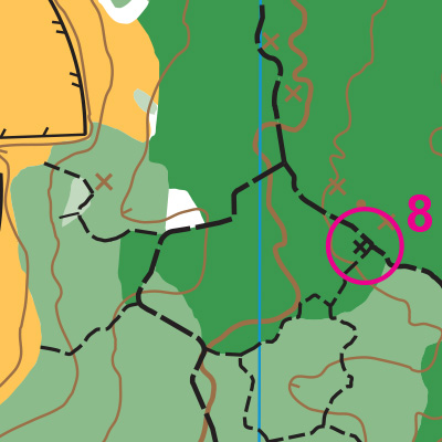
Note: This sample of the map is provided here for educational purposes only; the map shown here is not kept up-to-date.
The permanent orienteering courses at Wilburton Park were designed and installed by Elizabeth Beck as an International School Senior Project.
The purpose of providing these navigational and physical ratings below is to provide greater context for how challenging an orienteering course at this venue might be. For example, an advanced-level course at a local city park will be easier to complete than an advanced-level course in the mountains.