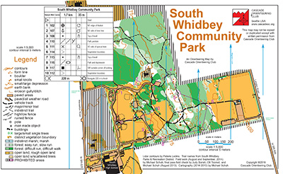
South Whidbey Community Park is a nice mix of open fields and a light but flexible trail network on a 1:5000 scale map. It is nicely self-contained, and when Cascade Orienteering Club has newcomer training on Whidbey Island, it happens here.
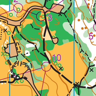
Navigationally, it consists of three zones. First, an open area of baseball diamonds, a central building called “The Crow’s Nest”, and a substantial playground with gazebo. This area usually does not, but my, include Whidbey Island High School directly to the south.
Surrounding this on at least two sides is an area of trails and vegetation with significant variety and some features in the lighter area, including knolls and some terrain changes. There is no specific perimeter trail. On the far east side of the map is another open, mowed space, accessible only by two woods trails. While this portion of the map is largely flat and mowed, there are some variations in contour and vegetation in one part that make this zone an interesting addition.
Turn-by-turn directions:
FROM THE SOUTH (SEATTLE, EVERETT):
The shortest route includes a FERRY which requires a fare. Calculate your fare price here. Note that Google Maps time estimates do not include time spent waiting for the scheduled ferry to arrive, nor for long ferry lines. Check the ferry schedule and cameras to estimate how long boarding the ferry might take.
Mukilteo ferry cameras and space available (to Whidbey Island)
Clinton ferry cameras and space available (back to the mainland, Seattle)
- Take I-5 North
- Take exit 182, for WA-525 N
- Continue on WA-525 N to the ferry terminal
- Note: drive in the ferry lane on the right side of the road as soon as it appears
- After disembarking the ferry, continue up the hill on WA-525 for about 3.9 miles
- Turn Right onto Maxwelton Rd
- After passing South Whidbey High School, take the next right into the park (Castle Park or South Whidbey Community Park)
- Parking is near the baseball fields
FROM THE NORTH (MT.VERNON):
You may either drive south to Mukilteo to take the ferry, or drive over the bridge through Deception Pass. Google Maps may show time estimates as fairly similar, though Google does not take into account how much time you might spend waiting to board a ferry. More information about the ferry route in the ‘From the South’ directions above.
To take the route using a ferry:
- Take I-5 South
- Take exit 182 to WA-526 and Mukilteo Speedway
- Turn right onto Mukilteo Speedway, and continue to the ferry.
- Note: drive in the ferry lane on the right side of the road as soon as it appears
- After disembarking the ferry, continue up the hill on WA-525 for about 3.9 miles
- Turn Right onto Maxwelton Rd
- After passing South Whidbey High School, take the next right into the park (Castle Park or South Whidbey Community Park)
- Parking is near the baseball fields
If you are driving from the north side of the island:
- Take WA-20 W (the main road) South, through the island
- The road will become WA-525 S
- Turn Left onto Maxwelton Rd
- After passing South Whidbey High School, take the next right into the park (Castle Park or South Whidbey Community Park)
- Parking is near the baseball fields