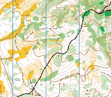
Jack Creek is a relatively small area. It covers a hillside that is rather flat and open near the campground at its western edge, and a lot of interesting landforms elsewhere. The lower part of the landscape is mostly open forest and wide open areas; elsewhere it ranges between open forest on spurs to dense vegetation in narrow valleys. You may encounter a few trails and a single forest road. It uses the ISOM 2017 symbol set with 1:10,000 scale and 5-meter contours.
Special Symbols: Green X is used most often for rootstocks, but also for stumps and logging debris piles. Green O is used for distinct trees.
Terrain and Vegetation: The map has fast and open meadows mixed with some open forest on a terrace near the main road, steeper slopes with some open runnable forest, and some less runnable terrain.
Note: Samples of the map are provided here for educational purposes only; the map shown here is not kept up-to-date.
The purpose of providing these navigational and physical ratings below is to provide greater context for how challenging an orienteering course at this venue might be. For example, an advanced-level course at a local city park will be easier to complete than an advanced-level course in the mountains.