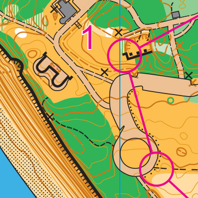
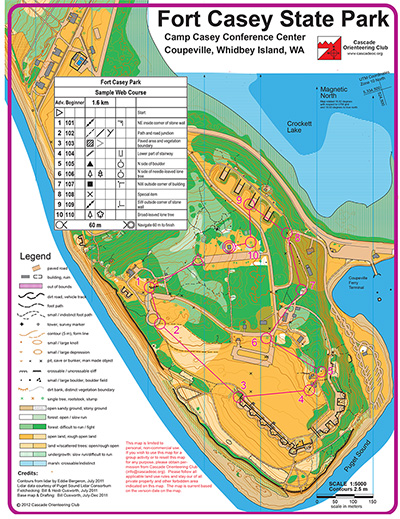
Navigational Challenge Rating: 3/10
The open grassy areas at Fort Casey State Park provide great visibility. There is forest here, though it is thick and there are relatively few trails. Orienteers will most likely take advantage of nearby paved paths to get around the map, while taking detours to find controls near buildings or bunkers.
Physical Challenge Rating: 4/10
Fort Casey State Park is made up of one long hill, with some steep areas. However, the heart of the park is fairly flat.
Turn-by-turn directions:
FROM SEATTLE via Mukilteo-Clinton ferry
- Take I-5 North
- Take exit 182 for I-405 N/WA-525
- Keep left at the fork and continue onto WA-525
- Keep left to continue on Mukilteo Speedway
- When you see a ferry lane on the right, enter it
- Take the Mukilteo-Clinton ferry
- From the ferry dock, continue on WA-525 for about 22 miles
- Turn left onto WA-20 W, continue for about 3.4 miles; the road will become S Engle Road
- Follow the orienteering signs and turn left into the park; there are multiple lots here, be sure to check the event page for the exact parking location
- A Discover Pass is required to Park at Fort Casey State Park
The ferry: the Mukilteo-Clinton ferry schedule changes each season, but it generally leaves every 30 minutes and takes 20 minutes to cross. Be aware that lines to get onto the ferry can take as long as 2 hours on a weekend morning.
FROM SEATTLE driving around (no ferry)
- Take I-5 North
- Take exit 230 to WA-20 W/Avon Cutoff
- Continue on WA-20
- When you get to Coupeville, turn right on S Main St.
- Main St. will turn into S Engle Rd.
- Follow the orienteering signs and turn left into the park; there are multiple lots here, be sure to check the event page for the exact parking location
- A Discover Pass is required to Park at Fort Casey State Park