Credits:
The map of the Maple Valley Legacy Site was created by John Brady. Much of the trail system, signs, and other elements of the entire property were curated by the Tahoma Orienteering Team, and particularly, the Menzie family. Tallie, Mark, Luke, Hank, Venna Menzie, and Sherri Brady deserve a lot of credit for not just helping the leaders of Maple Valley see a vision for this public space, but also for the hard work and details that cleaned this place up and turned it into a local gem. The park was originally slated to be an area with shopping and housing, and (for now due to its popularity) is teeming with public activity and perhaps on the track to a permanent preserved public forest and gathering space.
General Notes:
The Maple Valley Legacy Site is a 54 acre site situated along the Cedar to Green River Trail, and on the south east side of Lake Wilderness. The area has recently been a multi-use site, with the main attractions being the Maple Valley Farmers Market on most Saturdays, as well as a very popular children’s hiking trail known as The Gnome Trail, which is decorated with thousands of gnomes in various vignettes.
The Gnome Trail was originally part of a separate trail system across town and was quite popular in its original location. However, the original location was not ideal for a children’s hike due to the high mountain bike traffic it saw, as well as the long and confusing trail network that was required to navigate to reach the area. As a result of the excessive use, parking, and conflict in that area, the neighbors had successfully petitioned King County Parks to have the Gnome Trail removed. Rather than have all of the Gnomes removed and discarded, an effort by Sherri Brady and Tallie Menzie was made to petition the City of Maple Valley to allow them to gather and “re-home the gnome” to the Legacy Site. The City of Maple Valley agreed, and the Tahoma Orienteering Team went to work. Trails on the Legacy Site were created, trail signs were made by the Menzies, the and a park cleanup occurred to prepare the park. Then, a team of kids and parents went and gathered all of the Gnomes in their original location, took them home and cleaned them. A few days later, on the opening day of the Legacy Site’s new parking lot and park dedication, a “Rehome The Gnome” event was held. The cleaned gnomes were laid out in the parking lot and the community was encouraged to hike the Gnome trail and place the gnomes where and how they saw fit.
The event was so successful, and the subsequent popularity of the trail has led to the explosion of gnomes throughout the property, not just on the gnome trail! The trail has been the subject of TV shows, and many articles. The map of the area is titled “Tahoma Legacy” due to the significant role the Tahoma Orienteering families had in the creation of the map as well as the vision for the property. As a side benefit, it is a cute little orienteering venue for simple little fun events such as the WIOL series training day.
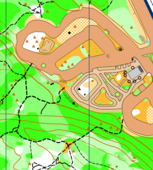
Mapping Conventions:
Standard ISSprOM conventions were used with the exception of forest trails, which the black trail symbol was used instead of the brown trail symbol. Map scale is 1:4000.
Note: Samples of the map are provided here for educational purposes only; the map shown here is not kept up-to-date.
The purpose of providing these navigational and physical ratings below is to provide greater context for how challenging an orienteering course at this venue might be. For example, an advanced-level course at a local city park will be easier to complete than an advanced-level course in the mountains.
https://maps.app.goo.gl/M7dAaA2SPqhV6tEq7