The Quincy Lakes map is owned by Peteris Ledins and maintained by Ott Toomet, who have generously allowed us to use it for some of our events.
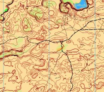
- ISOM 2017-2 symbols are used. This map was first created in 2013, but was updated significantly in 2020. A previous version of the map can be seen here: http://www.5z.com/urban/gadget/rg2/#131
- Vegetation: hard to cross and very hard to cross undergrowth with vertical stripes usually denotes sage bush or other smaller desert vegetation. The exception is near water where water-thirsty plants create hard to cross vegetation.
- Green forest describes higher vegetation, including some trees.
- There are several more distinct trees mapped with the green circle symbol; smaller but distinct bushes are mapped with a green dot.
- There are plenty of cliff faces; please don’t try to cross uncrossable cliffs.
- Ground cover is rocky, be careful with running. More rocky outcrops are marked as rocky ground symbol.
- Rocky ground/bare rock/knoll/rock/cliff – these all can describe rocky features.
- Rock – if the consistency is more uniform.
- Knoll – if it is composed of something that resembles a pile of rocks.
- Small outcrops of rocky ground – very small knolls when the elevation change is insignificant (<1m) yet noticable.
- Cliffs on contour line means that there is significant height and uniform appearance. However, if the cliff is small, but noticeable, or not very uniform, we have used rocky ground symbol cover on contour line.
- Bare rock has been used on uniform rocky features.
- Sometimes you can see rocky “walls” – linear but natural features – when they are uniform, bare rock is used, when less so – rocky ground in the shape of the feature.
Note: Samples of the map are provided here for educational purposes only; the map shown here is not kept up-to-date.
The purpose of providing these navigational and physical ratings below is to provide greater context for how challenging an orienteering course at this venue might be. For example, an advanced-level course at a local city park will be easier to complete than an advanced-level course in the mountains.