North SeaTac Park is a unique park–an answer to the question, “What would happen if all the people and their houses disappeared from a neighborhood?” There’s a mostly intact grid system of overgrown streets, trees and other vegetation that have grown back withe a vengeance, and open, grassy areas with intermittent vegetation clusters that are easy to navigate through if you don’t make a parallel feature error.
We typically start from the northeast area of the park, where there is ample parking and permanent restrooms. There is one busy street mid-course (on the longer courses), which usually has a crossing guard as a volunteer role.
ABOUT THE PERMANENT COURSE
This venue features a permanent course, which you can do at any time! To try it out, print the PDF map and control descriptions below (or simply open them on your smart phone), read the instructions on the permanent course page, and have fun!
- Print/view North SeaTac map Control 19 is missing.
- Print/view North SeaTac control descriptions (needed to complete the permanent course)
- Introduction-Orienteering Permanent Course at North SeaTac Park
CascadeOC supports many permanent courses over a large geographic area and our volunteers have limited time to keep up with maintenance. If you observe any damaged, obscured, or missing markers, or if you can help regularly monitor and maintain this permanent course, please let us know. Thanks for your help!
To find more venues with permanent courses, visit the Map of Maps page, where each permanent course is marked by a yellow pin.
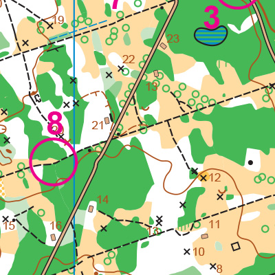
Note: Samples of the map are provided here for educational purposes only; the map shown here is not kept up-to-date.
The permanent orienteering courses at North SeaTac Park were designed and installed as a Boy Scout Eagle Award Service Project by Ryan Breseman, Boy Scout Troop 579.
The purpose of providing these navigational and physical ratings below is to provide greater context for how challenging an orienteering course at this venue might be. For example, an advanced-level course at a local city park will be easier to complete than an advanced-level course in the mountains.