Madrona School is a more complex variation of the typical non-college school map, with buildings and a few prominent trails on a large scale map (1:2,500 scale). But in this case, there are two campuses, linked by several trails on a steep slope. This doubles the ability for campus sprint course design, while also providing a physical challenge on the slope.
As an operating elementary/middle school, it should not be used during school hours.
ABOUT THE PERMANENT COURSE
This venue features a permanent course, which you can do at any time! To try it out, print the PDF map and control descriptions below (or simply open them on your smart phone), read the instructions on the permanent course page, and have fun!
- Print/view Madrona K-8 School map Posted Aug 2021
- Print/view Madrona K-8 School control descriptions (needed to complete the permanent course)
- Introduction-Orienteering Permanent Course at Madrona K-8 School
CascadeOC supports many permanent courses over a large geographic area and our volunteers have limited time to keep up with maintenance. If you observe any damaged, obscured, or missing markers, or if you can help regularly monitor and maintain this permanent course, please let us know. Thanks for your help!
To find more venues with permanent courses, visit the Map of Maps page, where each permanent course is marked by a yellow pin.
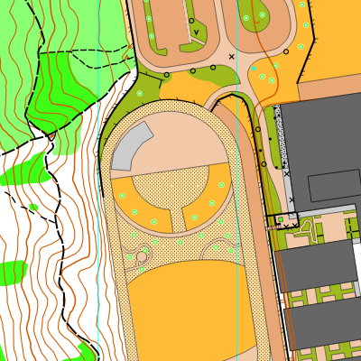
Note: Samples of the map are provided here for educational purposes only; the map shown here is not kept up-to-date.
The permanent orienteering courses at Madrona School were designed and installed by Madrona students and parents.
Do not use the map during school hours (8:30am – 4:30pm).
The purpose of providing these navigational and physical ratings below is to provide greater context for how challenging an orienteering course at this venue might be. For example, an advanced-level course at a local city park will be easier to complete than an advanced-level course in the mountains.