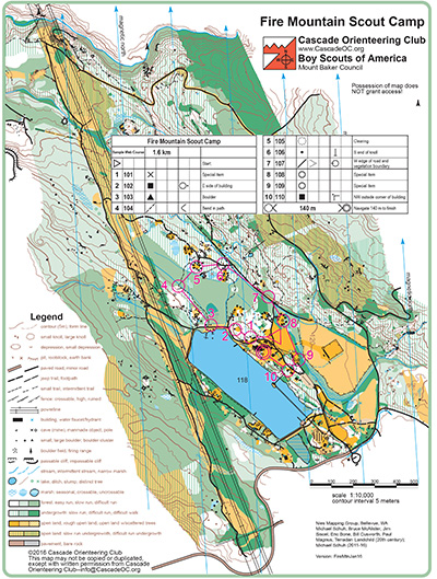
Fire Mountain Scout Camp is rugged terrain with some buildings, a lake, and a power line. Much of the accessible part of this map is hashed green (difficult run) which often translates into “acres of sword ferns”–you can lope through them, but it’s not quite running. And there’s a lot to see in there, including knolls, boulders and rootstocks. There is even a small cave on the property.
Closer in to civilization are a variety of small buildings, clustered in groups. You know you’re at a scout cabin, but which one? Mowed grassy areas are good year-round, but unmowed grass in the open field near the stream tends to get a bit swampy in winter–still traversable, but bring a spare pair of shoes!
Note: Samples of the map are provided here for educational purposes only; the map shown here is not kept up-to-date. The course shown is a Beginner/Intermediate course, and actual controls do not exist in the terrain.
The purpose of providing these navigational and physical ratings below is to provide greater context for how challenging an orienteering course at this venue might be. For example, an advanced-level course at a local city park will be easier to complete than an advanced-level course in the mountains.